Shenandoah Farms, Virginia
| Shenandoah Farms, Virginia | |
|---|---|
| Census-designated place | |
 Shenandoah Farms  Shenandoah Farms  Shenandoah Farms Location within the Commonwealth of Virginia | |
| Coordinates: 38°58′51″N 78°2′47″W / 38.98083°N 78.04639°WCoordinates: 38°58′51″N 78°2′47″W / 38.98083°N 78.04639°W | |
| Country |
|
| State |
|
| County |
|
| Area | |
| • Total | 11.5 sq mi (29.7 km2) |
| • Land | 11.3 sq mi (29.3 km2) |
| • Water | 0.2 sq mi (0.4 km2) |
| Elevation | 800 ft (200 m) |
| Population (2010) | |
| • Total | 3,033 |
| • Density | 268/sq mi (103.4/km2) |
| Time zone | Eastern (EST) (UTC-5) |
| • Summer (DST) | EDT (UTC-4) |
| ZIP codes | 22630, 22642 |
| FIPS code | 51-71810 |
| GNIS feature ID | 2629750 |
Shenandoah Farms is an unincorporated community and census-designated place in northeastern Warren County, Virginia, United States. A small portion extends into neighboring Clarke County. The population as of the 2010 United States Census was 3,033.[1] It is a recreational community built on the western slope of Blue Ridge Mountain and the banks of the Shenandoah River.
References
- ↑ "Geographic Identifiers: 2010 Demographic Profile Data (G001): Shenandoah Farms CDP, Virginia". U.S. Census Bureau, American Factfinder. Retrieved August 26, 2015.
Municipalities and communities of Warren County, Virginia, United States | ||
|---|---|---|
| Town | 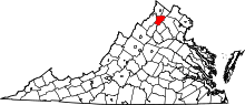 | |
| CDPs | ||
| Unincorporated communities |
| |
| Footnotes | ‡This populated place also has portions in an adjacent county or counties | |
Municipalities and communities of Clarke County, Virginia, United States | ||
|---|---|---|
| Towns | 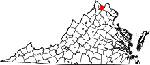 | |
| CDPs | ||
| Unincorporated communities | ||
| Footnotes | ‡This populated place also has portions in an adjacent county or counties | |
This article is issued from Wikipedia - version of the 6/9/2016. The text is available under the Creative Commons Attribution/Share Alike but additional terms may apply for the media files.