Shelter Cove Airport
| Shelter Cove Airport | |||||||||||
|---|---|---|---|---|---|---|---|---|---|---|---|
|
2012 photo | |||||||||||
| IATA: none – ICAO: none – FAA LID: 0Q5 | |||||||||||
| Summary | |||||||||||
| Airport type | Public | ||||||||||
| Operator | Shelter Cove Resort | ||||||||||
| Location | Shelter Cove, California | ||||||||||
| Elevation AMSL | 69 ft / 21 m | ||||||||||
| Coordinates | 40°01′40″N 124°04′24″W / 40.02778°N 124.07333°WCoordinates: 40°01′40″N 124°04′24″W / 40.02778°N 124.07333°W | ||||||||||
| Runways | |||||||||||
| |||||||||||
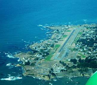
Shelter Cove Airport (FAA LID: 0Q5) is a public airport located in Shelter Cove, serving Humboldt County, California, USA. This general aviation airport covers 50 acres and has one runway.
The proximity to the ocean and on-field restaurant make the Shelter Cove Airport a popular fly-in destination when weather permits.
Accidents and incidents
- On 28 June 1971, Douglas C-47 N90627 of Lake Riverside Estates crashed on take-off on a domestic non-scheduled passenger flight to San Jose International Airport. Seventeen of the 24 people on board were killed. The cause of the accident was that flight was attempted with the rudder and elevator gust locks in place. Inadequate pre-flight inspection was a contributory factor.[1]
References
- ↑ "N90627 Accident description". Aviation Safety Network. Retrieved 19 September 2010.
External links
- Shelter Cove Airport Association
- The Chart Room - on-field restaurant
- Live Webcams at Shelter Cove Airport
- Resources for this airport:
- FAA airport information for 0Q5
- AirNav airport information for 0Q5
- FlightAware airport information and live flight tracker
- SkyVector aeronautical chart for 0Q5
This article is issued from Wikipedia - version of the 9/9/2016. The text is available under the Creative Commons Attribution/Share Alike but additional terms may apply for the media files.