Sheep River (Alberta)
| Sheep River | |
|---|---|
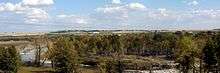 Sheep River before the confluence with Highwood River | |
| Country |
|
| Basin | |
| Main source |
Elbow-Sheep Wildland Provincial Park 2,100 meters (6,900 ft) 50°40′22″N 114°57′26″W / 50.67278°N 114.95736°W |
| River mouth |
Highwood River 983 meters (3,225 ft) 50°44′24″N 113°51′17″W / 50.73998°N 113.85475°WCoordinates: 50°44′24″N 113°51′17″W / 50.73998°N 113.85475°W |
| Physical characteristics | |
| Discharge |
|
The Sheep River is located in southwestern Alberta, Canada, and is part of the Bow River watershed. The river begins in the mountain valleys of Elbow-Sheep Wildland Provincial Park,[2] passes through Sheep River Provincial Park, and joins with the Highwood River about 8 km east of Okotoks. The Sheep provides drinking water for the towns of Turner Valley, Black Diamond, and Okotoks.
Tributaries
From origin to mouth, the Sheep River receives water from the following tributaries:
- Rae Creek (from Mount Rae)
- Burns Creek
- Cliff Creek
- Junction Creek
- Bluerock Creek
- Gorge Creek
- Dyson Creek
- March Creek
- Coal Creek
- Wolf Creek
- Long Prairie Creek
- Macabee Creek
- Waite Valley Creek
- Lineham Creek
- Turner Valley
- Threepoint Creek
- Spring Creek
- Wilson Coulee
See also
References
- ↑ Alberta Environment. Sheep River at Black Diamond
- ↑ Elbow-Sheep Wildland Provincial Park
External links
This article is issued from Wikipedia - version of the 6/11/2016. The text is available under the Creative Commons Attribution/Share Alike but additional terms may apply for the media files.