Shacklewell

Coordinates: 51°33′14″N 0°04′19″W / 51.554°N 0.072°W

Shacklewell was a hamlet that developed on Shacklewell Lane in the modern London Borough of Hackney.
The settlement is now usually seen as being part of Dalston which was originally a separate hamlet 500 yards to the south and also part of the Ancient Parish of Hackney.
Shacklewell took its name from "some springs or wells which were of high repute in former days, but the very site of which is now forgotten."[1]
Shacklewell has never been an administrative unit, and partly for that reason its extent has only ever been nebulously understood. For a brief time its sphere of influence extended north and north-west beyond its village core but Shacklewell is now mostly forgotten as a place name in everyday use, though the historic street pattern of the original hamlet remains.
History
The village was one of four small villages within the Parish of Hackney, (Dalston, Newington, Shacklewell, and Kingsland), which were all grouped for assessment purposes, together having only as many houses as the village of Hackney. The village of Shacklewell was settled on the eponymous village green,[2] along Shacklewell Lane.[3]
Shacklewell lay a little over 500 yards north of the hamlet of Dalston, which stood on Dalston Lane, with which it was linked by Cecilia Road.
Shacklewell had a manor house, which at one time was occupied by the Heron family.[1] Cecilia More, the youngest daughter of Sir Thomas More, the Roman Catholic martyr, married into the family in 1525. The house was later occupied by the Tyssen family, who owned large parts of Hackney.
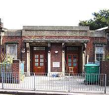
One municipal building still standing is the former Shacklewell Washing Baths. This was a communal bath and washhouse. Simple bathhouses like these were once of great importance. Even into the 1960s, in some working-class areas of London many dwellings did not have their own bathrooms.
Largely residential in the mid-19th Century, the district gained some light industry later on, including Eyre & Spottiswoode's printworks and a saw mill. Although some industry remains, largely now in Turkish hands, Shacklewell has been superseded as a commercial centre by neighbouring Stoke Newington and Dalston.
Growth and loss of sphere of identity
During the 19th century the area was urbanising and local identities were more fluid than today. For some of this period, Shacklewell was informally considered to extend north to include Rectory Road, Stoke Newington Common, the northern end of Amhurst Road and in some places both sides of Stoke Newington Road.
That sphere of self-identification has been completely lost. It is no longer common for a Londoner to refer to themselves as living in Shacklewell, so in its way the district is an illustration of the mutable nature of place names in the capital.
Residents of the village core and immediate surroundings – largely in the E8 postcode – self-identify as living in Dalston while those in the former extended sphere of influence – within N16 – consider themselves to belong to Stoke Newington.
Electoral Ward
There is a Shacklewell electoral ward for Hackney Council, which, as electoral wards require roughly equal electorates, corresponds only very roughly to the area after which it is named.
The post-2014 ward boundaries straddle Stoke Newington Road, with the village core and its immediate surroundings (now part of Dalston) to the east, while the area west of the road is the southernmost part of Stoke Newington
Transport
The nearest London Overground station is the Dalston Kingsland railway station.
Education
Schools in the area include the Petchey Academy, located on the site of the former Kingsland Secondary School.
Nearest places
References
- 1 2 Walford, Edward. Old and New London: A Narrative of Its History, Its People, and Its Places. 5. Cassell, Petter & Galpin. p. 530. Retrieved 2016-10-28.
- ↑ Hackney: Dalston and Kingsland Road, A History of the County of Middlesex: Volume 10: Hackney (1995), pp. 28-33 accessed: 7 December 2007
- ↑ Hackney: Shacklewell, A History of the County of Middlesex: Volume 10: Hackney (1995), pp. 35-38 accessed: 11 December 2007
| Districts | 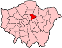 | |
|---|---|---|
| Attractions | ||
| Parks and open spaces | ||
| Street markets | ||
| Constituencies | ||
| Tube and rail stations | ||
| Other topics | ||