Sgùrr a' Mhàim
| Sgùrr a' Mhàim | |
|---|---|
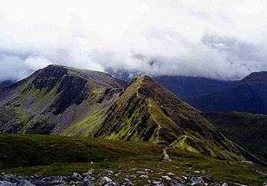
 Sgùrr a' Mhàim with its quartzite cap seen from the Devil’s Ridge | |
| Highest point | |
| Elevation | 1,099 m (3,606 ft) [1] |
| Prominence | 316 m (1,037 ft) |
| Parent peak | Binnein Mòr |
| Listing | Munro, Marilyn |
| Coordinates | 56°45′21″N 5°00′14″W / 56.7559°N 5.0038°WCoordinates: 56°45′21″N 5°00′14″W / 56.7559°N 5.0038°W |
| Naming | |
| Translation | Peak of the large rounded hill (Gaelic) |
| Pronunciation |
Scottish Gaelic: [ˈs̪kuːrˠ ə ˈvajm] English approx: skuer uh vime |
| Geography | |
| Location | Highland, Scotland |
| Parent range | Mamores |
| OS grid | NN164667 |
| Topo map | OS Landranger 41, OS Explorer 392 |
| Listed summits of Sgùrr a' Mhàim | ||||
| Name | Grid ref | Height | Status | |
|---|---|---|---|---|
| Sgùrr an Iubhair | NN165655 | 1001 m (3284 ft) | Munro Top | |
| Stob Choire a’ Mhàil | N163659 | 990 m (3248 ft) | Munro Top | |
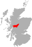
Sgùrr a' Mhàim, (pronounced sgur-a-vam), is a Scottish mountain situated five and a half kilometres north north-west of Kinlochleven in the Lochaber region of the Highland area.
Overview
With a height of 1099 metres (3605 feet) Sgùrr a' Mhàim is a Munro and the second highest peak in the Mamores. It is a distinctive mountain being well seen up Glen Nevis from Fort William with its capping of quartzite stones catching the eye and giving it a light grey appearance which can be mistaken for a covering of snow. Surprisingly its Gaelic name gives no mention of these distinctive white rocks, being translated as "Peak of the large rounded hill". When viewed from Glen Nevis it looks like a great breast although the name can also be translated as "Peak of the Pass"[2]
Geography
Sgùrr a' Mhàim is probably best known as the first or last peak of the “Ring of Steall”, a popular ridge walk taking in the other Munros of An Gearanach, Stob Coire a' Chàirn and Am Bodach. It is linked to the main spine of the Mamore group on its southern side by its most striking feature, The Devil’s Ridge, which is a one kilometre undulating ridge with a few exposed sections which require care. The most difficult part is (an avoidable rock gap) known as "The Bad Step" with well-known Scottish hill walker Hamish Brown commenting,
| “ | The ‘Bad Step’ on the ridge is perhaps exaggerated - it can be jumped across. If you missed of course, a couple of bounces would land you down in the corries.[3] | ” |
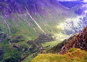
The Devil's Ridge has its own peak at the midpoint called Stob Choire a' Mhàil (990 metres) and then carries on to link to Sgor an Iubhair (Peak of the Yew; sometimes spelt Sgùrr an Iubhair), a 1001 m peak that briefly gained Munro status in 1981 only to lose it again in 1997. When viewed from the ridge Sgor an Iubhair looks every inch a separate distinctive mountain (see picture below). Both the above peaks are listed as "tops" of Sgùrr a' Mhàim in the Munro Tables. Sgùrr a' Mhàim's northern side contrasts to its southern flank (where the Devil’s Ridge is). Caution is needed around the northern slopes as they drop steeply to Glen Nevis, here there are two fine corries which end abruptly in cliffs which fall steeply into the Nevis gorge.
Ascents
Despite the difficulties on the northern flank, it is from that side that the mountain can be ascended directly using one of the three ridges that are thrown down to the glen. The most popular of these is up the north west ridge from Achriabhach (grid reference NN145683) where there is a car park but it is also possible to ascend from upper Glen Nevis via the north east or east ridges which spring from the Allt Coire a’ Mhàil above the An Steall Ban waterfall, both these routes require some scrambling. Any visit to Sgùrr a' Mhàim should include a crossing of the infamous Devil's Ridge[4] and a more circuitous ascent goes up to the head of Coire a' Mhusgain from Achriabhach to cross the ridge to the summit. The summit cairn is substantial being made up of light coloured quartzite stones and gives a very good view of the southern side of Ben Nevis and also an aerial view down into Glen Nevis.
References
- The Munros (SMC Guide), Donald Bennett et al., ISBN 0-907521-13-4
- 100 Best Routes on Scottish Mountains, Ralph Storer, ISBN 0-7515-0300-2
- The High Mountains of Britain and Ireland, Irvine Butterfield, ISBN 0-906371-30-9
- Hamish’s Mountain Walk, Hamish Brown, ISBN 1-898573-08-5
- The Munros, Scotland's Highest Mountains, Cameron McNeish, ISBN 1-84204-082-0
- The Magic Of The Munros, Irvine Butterfield, ISBN 0-7153-2168-4
Footnotes
- ↑ "walkhighlands Sgurr a'Mhaim". walkhighlands.co.uk. 2013. Retrieved 25 November 2013.
- ↑ "The Magic Of The Munros" Pages 61 (Gives details on name translation).
- ↑ "Hamish‘s Mountain Walk" Page 164 (Gives quote on Devils Ridge).
- ↑ "The Magic Of The Munros" Pages 61 (Butterfield says the crossing of the Devils Ridge is de rigueur).
 | Nevis range | 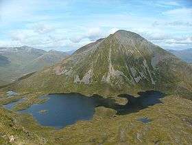 | |
|---|---|---|---|
| Mamores | |||
| Grey Corries |
| ||
| Alder/Ardverikie |
| ||
| Ossian/Treig |
| ||