Am Bodach
| Am Bodach | |
|---|---|
 Am Bodach seen from Stob Coire a' Chàirn, 1.5 km to the NE. | |
| Highest point | |
| Elevation | 1,032 m (3,386 ft) [1] |
| Prominence | 151 m (495 ft) |
| Parent peak | Sgurr a' Mhàim |
| Listing | Munro, Marilyn |
| Coordinates | 56°44′27″N 4°59′02″W / 56.74086°N 4.98394°WCoordinates: 56°44′27″N 4°59′02″W / 56.74086°N 4.98394°W |
| Naming | |
| Translation | The Old Man (Gaelic) |
| Pronunciation |
Scottish Gaelic: [əmˈpɔt̪əx] English approx: uhm bot-uhkh |
| Geography | |
| Parent range | Mamores |
| OS grid | NN176650 |
| Topo map | OS Landranger 41, OS Explorer 392 |

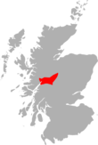
Am Bodach is a Scottish mountain which lies in the Mamores range, four kilometres north of Kinlochleven in the Highland council area.
Overview
Am Bodach is a Munro which reaches a height of 1032 metres (3386 feet) making it the 100th highest mountain in that classification,[2] it is situated on the main ridge of the Mamores in a central position and is the most accessible of the group. The closest approach to the mountain is from Kinlochleven to the south, however the mountain is often approached along its north eastern or eastern ridges as part of the highly rated “Ring of Steall” ridge walk which starts and finishes in Glen Nevis and climbs the other Munros of An Gearanach, Stob Coire a' Chàirn and Sgurr a' Mhàim.[3] Am Bodach translates from the Gaelic as “The Old Man”, this name was often given to a conspicuous hill overlooking a community and it was probably named by settlers at the head of Loch Leven which the mountain overlooks.[4] The mountain should not be confused with another Am Bodach at the eastern end of the Aonach Eagach ridge in Glen Coe.
Geography
Am Bodach is a fine looking mountain with a sharp peak formed by its three steep and rocky faces, the eastern face above the Coire na Ba is especially precipitous and craggy and holds patches of snow well into summer. Am Bodach has three ridges radiating from its summit, the western one connects to the former Munro of Sgurr an Iubhair (downgraded to a "Top" in the 1997 revisions) while the north eastern ridge, which is steep and rocky, connects to the Munro of Stob Coire a' Chàirn, it is along these two ridges that walkers undertaking the Ring of Steall walk will arrive and leave the mountain. A third ridge goes southerly over the minor top of Sgurr an Fhurain before descending steeply to Kinlochleven.
Ascents
The direct ascent of Am Bodach starts at sea level at Kinlochleven, although it is possible to drive to and park at Mamore Lodge saving 200 metres of ascent, the track goes north west for one kilometre along the old military road to Fort William built by General Caulfield,[5] which now carries the West Highland Way. The track is then left and it is a steep climb north east to the top of Sgurr an Fhurain and then north to the summit of Am Bodach. The view from the top takes in Glen Coe and Loch Leven, with Bidean nam Bian looking especially fine.[6]
References
- Donald J. Bennet (1985-01-01). The Munros: The Scottish Mountaineering, Club Hillwalkers' Guide. ISBN 978-0-907521-13-6.
- Irvine Butterfield (1999). The Magic of the Munros. ISBN 978-0-7153-2168-3.
- Cameron McNeish (2006-09-01). Munros. ISBN 978-1-84204-082-9.
Footnotes
- ↑ "walkhighlands Am Bodach". walkhighlands.co.uk. 2013. Retrieved 22 November 2013.
- ↑ www.scottishsport.co.uk. Gives list of Munros in height order.
- ↑ www.ben-nevis.co.uk. Gives details of Ring of Steall walk.
- ↑ "The Magic Of The Munros" Page 58 Gives information on meaning of name.
- ↑ www.jbutler.org.uk. Confirms military road built by Caulfield.
- ↑ "The Munros" Page 67 Gives details of ascents.
 | Nevis range | 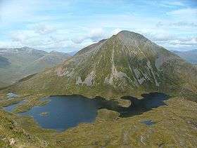 | |
|---|---|---|---|
| Mamores | |||
| Grey Corries |
| ||
| Alder/Ardverikie |
| ||
| Ossian/Treig |
| ||