Serrata, Calabria
| Serrata | |
|---|---|
| Comune | |
| Comune di Serrata | |
|
Parrocchia di San Pantaleone | |
 Serrata Location of Serrata in Italy | |
| Coordinates: 38°32′N 16°5′E / 38.533°N 16.083°ECoordinates: 38°32′N 16°5′E / 38.533°N 16.083°E | |
| Country | Italy |
| Region | Calabria |
| Province / Metropolitan city | Province of Reggio Calabria (RC) |
| Government | |
| • Mayor | Salvatore Vinci |
| Area | |
| • Total | 21.8 km2 (8.4 sq mi) |
| Population (Dec. 2004) | |
| • Total | 922 |
| • Density | 42/km2 (110/sq mi) |
| Demonym(s) | Serratesi |
| Time zone | CET (UTC+1) |
| • Summer (DST) | CEST (UTC+2) |
| Postal code | 89020 |
| Dialing code | 0966 |

Serrata is a comune (municipality) in the Province of Reggio Calabria in the Italian region Calabria, located about 60 kilometres (37 mi) southwest of Catanzaro and about 60 km northeast of Reggio Calabria. As of 31 December 2004, it had a population of 922 and an area of 21.8 square kilometres (8.4 sq mi).[1]
Serrata borders the following municipalities: Candidoni, Dinami, Laureana di Borrello, Mileto, San Pietro di Caridà.
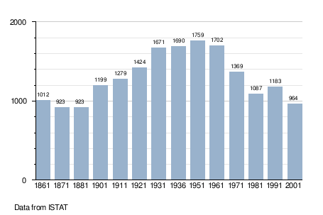
Demographic evolution
References
This article is issued from Wikipedia - version of the 1/31/2015. The text is available under the Creative Commons Attribution/Share Alike but additional terms may apply for the media files.