Seneca Rocks, West Virginia
| Seneca Rocks | |
|---|---|
| Unincorporated community | |
|
Community of Seneca Rocks, West Virginia at the confluence of Seneca Creek and the North Fork South Branch Potomac River. The "Seneca Rocks Discovery Center" is at the center of the photo which was taken from atop Seneca Rocks. | |
 Seneca Rocks  Seneca Rocks Location within the state of West Virginia | |
| Coordinates: 38°50′5″N 79°22′34″W / 38.83472°N 79.37611°WCoordinates: 38°50′5″N 79°22′34″W / 38.83472°N 79.37611°W | |
| Country | United States |
| State | West Virginia |
| County | Pendleton |
| Elevation | 1,568 ft (478 m) |
| Time zone | Eastern (EST) (UTC-5) |
| • Summer (DST) | EDT (UTC-4) |
| GNIS feature ID | 1552243[1] |

Seneca Rocks is an unincorporated community located in Pendleton County, West Virginia, United States.[1] The community of Seneca Rocks — formerly known as Mouth of Seneca — lies along West Virginia Route 28/West Virginia Route 55 near the confluence of Seneca Creek and the North Fork South Branch Potomac River. The community also lies near Seneca Rocks, the crag from which it takes its name. Both lie within the Spruce Knob-Seneca Rocks National Recreation Area of the Monongahela National Forest.
Located at Seneca Rocks is the Sites Homestead (ca. 1839), now part of the Seneca Rocks Visitor Center and listed on the National Register of Historic Places in 2004.[2] Located nearby is the Boggs Mill (ca. 1830), listed in 2004.[2]
References
- 1 2 "Seneca Rocks". Geographic Names Information System. United States Geological Survey.
- 1 2 National Park Service (2010-07-09). "National Register Information System". National Register of Historic Places. National Park Service.
Municipalities and communities of Pendleton County, West Virginia, United States | ||
|---|---|---|
| Town | 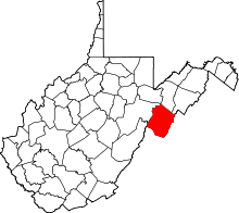 | |
| CDP | ||
| Unincorporated communities | ||
| Ghost towns | ||