Seminole, Florida
- Not to be confused with Seminole County, Florida in the Central region of the State of Florida.
| Seminole, Florida | |
|---|---|
| City | |
 Location in Pinellas County and the state of Florida | |
| Coordinates: 27°50′19″N 82°47′6″W / 27.83861°N 82.78500°WCoordinates: 27°50′19″N 82°47′6″W / 27.83861°N 82.78500°W | |
| Country |
|
| State |
|
| County | Pinellas |
| Area | |
| • Total | 5.6 sq mi (14.6 km2) |
| • Land | 5.1 sq mi (13.2 km2) |
| • Water | 0.5 sq mi (1.4 km2) |
| Elevation | 36 ft (11 m) |
| Population (2010) | |
| • Total | 17,233 |
| • Density | 3,100/sq mi (1,200/km2) |
| Time zone | Eastern (EST) (UTC-5) |
| • Summer (DST) | EDT (UTC-4) |
| ZIP codes | 33772-33778 |
| Area code(s) | 727 |
| FIPS code | 12-64975[1] |
| GNIS feature ID | 0290826[2] |
| Website |
www |

Seminole is a city in Pinellas County, Florida, United States. The population was 17,233 at the 2010 census,[3] up from 10,890 in 2000. St. Petersburg College has a campus in the city.
History
The first white settlement at Seminole was made in the 1840s.[4] The community was named after the Seminole Indians who once inhabited the area.[4] Seminole was incorporated in 1970.[5]
Seminole contains a water tower painted in 2000 by artist Tom Stovall. In late 2005, council members expressed dissatisfaction with the design, but residents spoke out in its favor, feeling it made Seminole unique and provided a good landmark for giving directions.[6][7]
Geography
Seminole is located at 27°50′19″N 82°47′6″W / 27.83861°N 82.78500°W (27.838502, -82.784913).[8] It is surrounded by Pinellas County enclaves in all directions. Its closest neighbors are Indian Rocks Beach to the northwest, Largo to the north, Pinellas Park to the east, St. Petersburg to the south, and Madeira Beach to the west. Its main arteries are State Road 694 and Alternate U.S. Highway 19. It embraces the lower half of the lower limb of Lake Seminole.
According to the United States Census Bureau, the city has a total area of 5.6 square miles (14.6 km2), of which 5.1 square miles (13.2 km2) is land and 0.54 square miles (1.4 km2) (9.58%) is water.[9]
Demographics
| Historical population | |||
|---|---|---|---|
| Census | Pop. | %± | |
| 1980 | 4,586 | — | |
| 1990 | 9,251 | 101.7% | |
| 2000 | 10,890 | 17.7% | |
| 2010 | 17,233 | 58.2% | |
| Est. 2015 | 18,153 | [10] | 5.3% |
As of the census[1] of 2000, there were 10,890 people, 5,989 households, and 2,701 families residing in the city. The population density was 4,402.1 inhabitants per square mile (1,702.3/km²). There were 7,297 housing units at an average density of 2,949.7 per square mile (1,140.6/km²). The racial makeup of the city was 96.61% White, 0.48% African American, 0.34% Native American, 0.85% Asian, 0.03% Pacific Islander, 0.41% from other races, and 1.28% from two or more races. Hispanic or Latino of any race were 2.25% of the population.
There were 5,989 households out of which 12.6% had children under the age of 18 living with them, 35.4% were married couples living together, 7.4% had a female householder with no husband present, and 54.9% were non-families. 49.1% of all households were made up of individuals and 33.8% had someone living alone who was 65 years of age or older. The average household size was 1.75 and the average family size was 2.48.
In the city the population was spread out with 11.8% under the age of 18, 3.8% from 18 to 24, 19.5% from 25 to 44, 21.3% from 45 to 64, and 43.6% who were 65 years of age or older. The median age was 59 years. For every 100 females there were 76.2 males. For every 100 females age 18 and over, there were 72.3 males.
The median income for a household in the city was $29,179, and the median income for a family was $39,491. Males had a median income of $29,237 versus $25,588 for females. The per capita income for the city was $20,951. About 5.1% of families and 9.0% of the population were below the poverty line, including 5.7% of those under age 18 and 9.7% of those age 65 or over.
In 2010 the mean income for a household in the city was $45,730, and the median income for a family was $63,260. The per capita income for the city was $29,862.
Notable people
- Angela Elwell Hunt, author
- Nicole Johnson, Miss America 1999
- Casey Kotchman, Major League Baseball player
- Brittany Lincicome, professional golfer, winner of the 2009 Kraft Nabisco Championship
- Randy Savage, pro wrestler
- Bobby Wilson, Major League Baseball player
- John Winter, meteorologist
Gallery
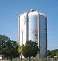 The Seminole water tower
 The lake and band shell at Seminole City Park
References
- 1 2 "American FactFinder". United States Census Bureau. Retrieved 2008-01-31.
- ↑ "US Board on Geographic Names". United States Geological Survey. 2007-10-25. Retrieved 2008-01-31.
- ↑ "Profile of General Population and Housing Characteristics: 2010 Demographic Profile Data (DP-1): Seminole city, Florida". U.S. Census Bureau, American Factfinder. Retrieved May 8, 2012.
- 1 2 Wright, Fred (Jul 30, 1966). "Seminole area history sketchy but booming". The Evening Independent. pp. 16A. Retrieved 1 November 2015.
- ↑ "Did you know?" (PDF). City of Seminole, Florida. Retrieved 25 July 2015.
- ↑ "City in a tizzy about the tank". <!. January 1, 2006.
- ↑ "Controversy over water tower mural". March 5, 2007.
- ↑ "US Gazetteer files: 2010, 2000, and 1990". United States Census Bureau. 2011-02-12. Retrieved 2011-04-23.
- ↑ "Geographic Identifiers: 2010 Demographic Profile Data (G001): Seminole city, Florida". U.S. Census Bureau, American Factfinder. Retrieved May 8, 2012.
- ↑ "Annual Estimates of the Resident Population for Incorporated Places: April 1, 2010 to July 1, 2015". Retrieved July 2, 2016.
- ↑ "Census of Population and Housing". Census.gov. Retrieved June 4, 2015.
External links
| Wikivoyage has a travel guide for Seminole (Florida). |
Municipalities and communities of Pinellas County, Florida, United States | ||
|---|---|---|
| Cities | 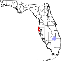 | |
| Towns | ||
| CDPs | ||
| Unincorporated communities | ||
| Ghost towns | ||