Segonzano
| Segonzano | |
|---|---|
| Comune | |
| Comune di Segonzano | |
|
View from the nearby Faver | |
 Segonzano Location of Segonzano in Italy | |
| Coordinates: 46°11′N 11°16′E / 46.183°N 11.267°ECoordinates: 46°11′N 11°16′E / 46.183°N 11.267°E | |
| Country | Italy |
| Region | Trentino-Alto Adige/Südtirol |
| Province / Metropolitan city | Trentino (TN) |
| Area | |
| • Total | 20.8 km2 (8.0 sq mi) |
| Elevation | 700 m (2,300 ft) |
| Population (Dec. 2004) | |
| • Total | 1,487 |
| • Density | 71/km2 (190/sq mi) |
| Time zone | CET (UTC+1) |
| • Summer (DST) | CEST (UTC+2) |
| Postal code | 38047 |
| Dialing code | 0461 |

Segonzano (German: Segunzan) is a comune (municipality) in Trentino in the northern Italian region Trentino-Alto Adige/Südtirol, located about 15 kilometres (9 mi) northeast of Trento. As of 31 December 2004, it had a population of 1,487 and an area of 20.8 square kilometres (8.0 sq mi).[1]
Segonzano borders the following municipalities: Sover, Grumes, Valda, Faver, Cembra, Lona-Lases, Bedollo and Baselga di Pinè.
Nearby is a spectacular geologic curiosity, the "Piramidi di Terra" pyramids created by erosion.
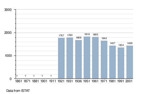
Demographic evolution
References

This article is issued from Wikipedia - version of the 10/4/2015. The text is available under the Creative Commons Attribution/Share Alike but additional terms may apply for the media files.