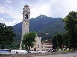
Tione di Trento
| Tione di Trento | |
|---|---|
| Comune | |
| Comune di Tione di Trento | |
 | |
 Tione di Trento Location of Tione di Trento in Italy | |
| Coordinates: 46°2′N 10°44′E / 46.033°N 10.733°ECoordinates: 46°2′N 10°44′E / 46.033°N 10.733°E | |
| Country | Italy |
| Region | Trentino-Alto Adige/Südtirol |
| Province / Metropolitan city | Trentino (TN) |
| Frazioni | Saone |
| Area | |
| • Total | 33.3 km2 (12.9 sq mi) |
| Elevation | 600 m (2,000 ft) |
| Population (Dec. 2004) | |
| • Total | 3,528 |
| • Density | 110/km2 (270/sq mi) |
| Demonym(s) | Tionesi |
| Time zone | CET (UTC+1) |
| • Summer (DST) | CEST (UTC+2) |
| Postal code | 38079 |
| Dialing code | 0465 |
| Website | Official website |
Tione di Trento (German: Taun, Teyen or Tillen) is a comune (municipality) in Trentino in the northern Italian region Trentino-Alto Adige/Südtirol, located about 30 kilometres (19 mi) west of Trento. As of 31 December 2004, it had a population of 3,528 and an area of 33.3 square kilometres (12.9 sq mi).[1]
The municipality of Tione di Trento contains the frazione (subdivision) Saone.
Tione di Trento borders the following municipalities: Ragoli, Villa Rendena, Preore, Comano Terme, Bleggio Superiore, Bondo, Bolbeno, Breguzzo, Zuclo, Roncone, Lardaro, Ledro and Pieve di Bono.
History
Until 1918, Tione was part of the Austrian monarchy (Austria side after the compromise of 1867), head of the district of the same name, one of the 21 Bezirkshauptmannschaften in the Tyrol province.[2] A post-office was opened in 1851.[3]
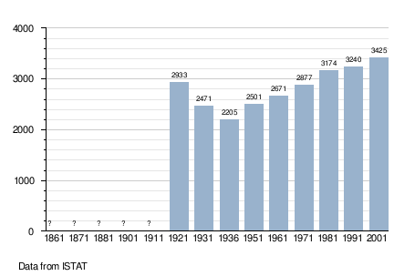
Demographic evolution
References
- ↑ All demographics and other statistics: Italian statistical institute Istat.
- ↑ Die postalischen Abstempelungen auf den österreichischen Postwertzeichen-Ausgaben 1867, 1883 und 1890, Wilhelm KLEIN, 1967
- ↑ Handbook of Austria and Lombardy-Venetia Cancellations on the Postage Stamp Issues 1850-1864, by Edwin MUELLER, 1961.
External links
- (Italian) Homepage of the city
