Sedgwick Avenue

Sedgwick Avenue is a major street in the Bronx, New York City. It runs roughly parallel to Jerome Avenue, the Major Deegan Expressway, and University Avenue. Sedgwick Avenue is one of the longest streets in the western part of the Bronx, running from Mosholu Parkway at the north to Macombs Dam Bridge at its southern end, about 800 feet (250 m) west of Yankee Stadium.
A smaller Sedgwick Avenue continues into Yonkers, north of Van Cortlandt Park and east of the Saw Mill River Parkway.
History
From the early 20th century until the 1970s, Sedgwick Avenue is one of the busiest thoroughfares in the Bronx, having streetcars, buses, and train stations. In around 1900, it was a popular road for weekend bicycle tours and military marches to Van Cortlandt Park.[1]
From 1918 to 1958, the Sedgwick Avenue elevated station operated at Webster Avenue.[2]
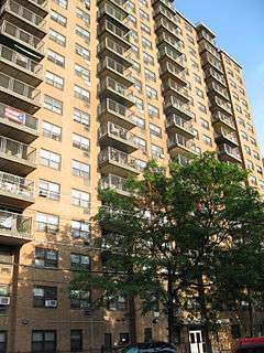
New York City Mayor Bill de Blasio signed a bill on February 26, 2016 renaming 42 streets and places in New York City.[3] One of the renamed blocks was a block where 1520 Sedgwick Ave is located which was renamed “Hip Hop Boulevard" after DJ Kool Herc who threw a "back to school jam " at 1520 Sedgwick Ave, and at that party, hip-hop began.[3] DJ Kool Herc had moved his parties to Cedar Park, "attracting b-boys and cool kids from across the Bronx [in] 1974."[4]
Route description
The avenue starts as a northbound service road, running north-south, to Major Deegan Expressway (Interstate 87) at around the Macombs Dam Bridge. Morris Heights, Bronx is adjacent to this section of the avenue. It splits northeast and becomes two-way at around West Tremont Avenue; Roberto Clemente State Park is at this intersection, and the University Woods, overlooking the Harlem River, a small wood land crested between Sedgwick and Cedar Avenues, is also nearby. Along this stretch, the Putnam Line had a station at Sedgwick Avenue. The NYPD's 44th Precinct is on Sedgwick Avenue at 169th Street. Sedgwick Avenue remains a primary thoroughfare through University Heights and Kingsbridge Heights; ZIP codes include 10463 and 10468. At Webster Avenue, the Sedgwick Avenue station was a train station on the abandoned section of the IRT Ninth Avenue Line from 1918 until 1958.[2] The New York City Housing Authority has a number of large apartment complexes along the avenue. The avenue then turns east, and runs near the west and north sides of the Jerome Park Reservoir. Mosholu Parkway intersects with Sedgwick Avenue at its northern end.
There are buses and formerly streetcars along the avenue. Bus routes include Bx1, Bx2, Bx3, Bx9, BxM3.[5]
This mostly two-way thoroughfare passes two historic sites:
- The Hall of Fame for Great Americans directly overlooks Sedgwick Avenue.[6]
- DJ Kool Herc is credited with helping to start hip hop and rap music at a house concert at 1520 Sedgwick Avenue.[4][7][8][9][10]
References
- ↑ Henry Mitchell MacCracken, The Hall of Fame: being the official book authorized by the New York University senate as a statement of the origin and constitution of the Hall of Fame, and of its history up to the close of the year 1900, p. 73 (G.P. Putnams' Sons, 1901), found at Google Books. Retrieved 4/11/11.
- 1 2 See IRT Ninth Avenue Line 9th Avenue El,Polo Grounds Shuttle, and New York Central Hudson Division Sedgwick Ave Station in Forgotten BronxTransit.
- 1 2 Low, Carver (February 26, 2016). "A block at 1520 Sedgwick Ave is renamed in honor of legendary DJ Kool Herc". Encyclopedia of Things. Retrieved February 26, 2016.
- 1 2 Chen, Anelise (October 26, 2016). "Wandering Work: A bustling new atlas illuminates the city's psychogeography". The Village Voice. p. 31.
- ↑ http://web.mta.info/nyct/maps/busbx.pdf
- ↑ Bronx Community College website Directions page. Retrieved 4/11/11.
- ↑ Borgya, A. (September 3, 2010) "A Museum Quest Spins On and On", New York Times. Retrieved 9/4/10.
- ↑ Dolnick, S. (September 6, 2010) "Hope for a Bronx Tower of Hip-Hop Lore", New York Times. Retrieved 9/6/10.
- ↑ (July 23, 2007) "An Effort to Honor the Birthplace of Hip-Hop", New York Times. Retrieved 9/3/10.
- ↑ (July 23, 2007) "1520 Sedgwick Avenue Honored as a Hip-Hop Landmark Today", XXL Magazine. Retrieved 9/3/10.
Coordinates: 40°51′37.59″N 73°54′40.74″W / 40.8604417°N 73.9113167°W