Secondcreek, West Virginia
| Secondcreek, West Virginia | |
|---|---|
| Unincorporated community | |
 Secondcreek, West Virginia  Secondcreek, West Virginia | |
| Coordinates: 37°39′55″N 80°27′14″W / 37.66528°N 80.45389°WCoordinates: 37°39′55″N 80°27′14″W / 37.66528°N 80.45389°W | |
| Country | United States |
| State | West Virginia |
| County | Monroe |
| Elevation | 1,873 ft (571 m) |
| Time zone | Eastern (EST) (UTC-5) |
| • Summer (DST) | EDT (UTC-4) |
| ZIP code | 24974 |
| Area code(s) | 304 & 681 |
| GNIS feature ID | 1555586[1] |
Secondcreek is an unincorporated community in Monroe County, West Virginia, United States. Secondcreek is northeast of Union. Secondcreek has a post office with ZIP code 24974. Post office was closed in 2010.[2]
The community was named after nearby Second Creek.[3]
Resource and Heritage
Second Creek is an excellent trout stream although the native brook trout is in greatly reduced numbers compared to the brown trout and rainbow trout recently introduced. Rodgers Mill is a fly fishing only site.Second Creek is stocked every April. Fly anglers can access the waters using County Route 219/3 and County Route 3/7 from US Route 219.
At one time in its history, more than twenty mills for powder, grist, lumbering and finishing were on this creek.
Reed's Mill and the Nickell Homestead and Mill are listed on the National Register of Historic Places.[4]
References
- ↑ "US Board on Geographic Names". United States Geological Survey. 2007-10-25. Retrieved 2008-01-31.
- ↑ ZIP Code Lookup
- ↑ Kenny, Hamill (1945). West Virginia Place Names: Their Origin and Meaning, Including the Nomenclature of the Streams and Mountains. Piedmont, WV: The Place Name Press. p. 561.
- ↑ National Park Service (2010-07-09). "National Register Information System". National Register of Historic Places. National Park Service.
External links
- Second Creek is directly served by its watershed, "Friends of the Second Creek"
- Second Creek is a tributary of the Greenbrier River. Its watershed is called the Greenbrier River Watershed Association. Thanks to the contribution of waterbodys like Second Creek, the Greenbrier comprises about 30% of the New River's volume.
- The Greenbrier River is a major tributary for the New River watershed.
Municipalities and communities of Monroe County, West Virginia, United States | ||
|---|---|---|
| Towns | 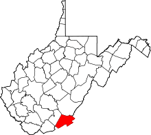 | |
| Unincorporated communities |
| |
| Ghost town | ||
| Footnotes | ‡This populated place also has portions in an adjacent county or counties | |