Savinja
| Savinja | |
|---|---|
 The Savinja in Celje, before it turns south to Laško | |
| Country | Slovenia |
| Basin | |
| Main source |
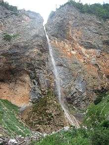
Rinka Falls 1,310 m (4,300 ft)[1] |
| River mouth | Sava |
| Basin size | 1,848 m3 (65,300 cu ft)[1] |
| Physical characteristics | |
| Length | 102 km (63 mi)[1] |

The Savinja (pronounced [saˈʋiːnja]) is a river in northeast Slovenia which flows mostly in the Upper and Lower Savinja Valley (Slovene: Zgornja in Spodnja Savinjska dolina) and through the cities of Celje and Laško. The Savinja is the main river of the Savinja Alps (Sln. Savinjske Alpe). It flows into Sava River at the town of Zidani Most. It has often flooded, such as in the 1960s, 1990, and 1995. The Savinja has a length of 102 kilometres (63 mi).[1]
Sources
The stream is created by Rinka Falls, which flows along a regulated riverbed to the lower end of the Logar Valley, where it flows into Jezera Creek, from which point it becomes the Savinja River. This spring has been proclaimed a natural heritage object, and Rinka Falls is one of the most beautiful and best-known waterfalls in Slovenia. It is the highest waterfall of the 20 waterfalls in the Logar Valley and is visited throughout the year. In the winter it is popular for ice-climbers. The best view of the waterfall is from Kamnik Saddle (Slovene: Kamniško sedlo).
Tributaries
The main tributaries of the Savinja are the Jušef and the Klobaša at Solčava, the Lučnica at Luče, the Ljubnica at Ljubno, the Dreta at Nazarje, the Paka at Šmartno ob Paki, and the Ložnica and Voglajna with the Hudinja at Celje.
Water quality
The quality of water is first-class to Radmirje, then it falls to second class and after to third.
Hydronym and etymology
The name Savinja (attested in written sources in 980 as Sovuina) is derived from *Savьn′a, in turn derived from the hydronym Sava, of which it is a tributary. The German name Sann was attested later. In the local dialect, the river is known as Sáu̯ńe. The form *Savьn′a should have yielded Savnja as the current Slovene name, but it was reshaped on the model of Hudinja. The name is believed to ultimately not be of Slavic origin, but of older pre-Slavic origin.[2]
The German name Sann was also used in some older English sources; for example, in the ninth edition of Encyclopædia Britannica from 1911.
Some other names for the river include:
- fluvius Sana (9th century)[3]
- Souina (980)[3]
- inter fluenta Souuuę et Sounę (1016)[3]
- Seuna (1016)[3]
- Souna (1025,1028)[3]
- inter fluenta Souuuae et Sounae (1028)[3]
- Sounital (1042)[3]
The Roman goddess Adsaluta, whose altars were found in the area of the settlement of Sava, was long identified with the Savinja. Modern scholars have rejected the connection.[4]
Life along the river
Raftsmen from Ljubno traveled along the river until the 1950s. In their memory, a bronze sculpture of a raftsman (Splavar), created in 1961 by Boris Kalin, stands on the river's left bank in Celje.
References
| Wikimedia Commons has media related to Savinja. |
- 1 2 3 4 "Reke, dolge nad 25 km, in njihova padavinska območja" [Rivers, longer than 25 km, and their catchment areas] (in Slovenian and English). Statistical Office of the Republic of Slovenia. 2002.
- ↑ Snoj, Marko. 2009. Etimološki slovar slovenskih zemljepisnih imen. Ljubljana: Modrijan and Založba ZRC, p. 368.
- 1 2 3 4 5 6 7 Udolph, Jürgen (2003–2004). "Alteuropa in Kroatien: der Name der Sava/Save" (PDF). Folia onomastica Croatica (in German). Retrieved 2009-04-19.
- ↑ Šašel Kos, Marjeta (2009). "Reka kot božanstvo - Sava v antiki" [River as a Deity – The Sava in Antiquity]. In Barachini, Jožef. Ukročena lepotica: Sava in njene zgodbe [The Tamed Beauty: The Sava and Its Stories] (PDF) (in Slovenian and English). Sevnica: Javni zavod za kulturo, šport, turizem in mladinske dejavnosti. pp. 42–50 (44–46). ISBN 978-961-92735-0-0.
External links
- Condition of Savinja at several locations (proceeding from its upper strem to its lower stream):
- Nazarje - graphs, in the following order, of water level and flow data for the past 30 days (taken in Nazarje by ARSO)
- Letuš - graphs, in the following order, of water level, flow and temperature data for the past 30 days (taken in Letuš by ARSO)
- Medlog - graphs, in the following order, of water level and temperature data for the past 30 days (taken in Medlog by ARSO)
- Laško - graphs, in the following order, of water level, flow and temperature data for the past 30 days (taken in Laško by ARSO)
- Veliko Širje - graphs, in the following order, of water level, flow and temperature data for the past 30 days (taken in Veliko Širje by ARSO)
Hydrography of Slovenia | ||
|---|---|---|
| Rivers |
|  |
| Streams | ||
| Waterfalls | ||
| Lakes | ||
| Wetlands | ||
| Sea | ||
| River valleys |
| |
| Canyons and gorges |
| |
Coordinates: 46°05′N 15°10′E / 46.083°N 15.167°E