Kobilje Creek
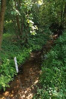
Kobilje Creek (Hungarian: Kebele,[1] Slovene: Kobiljski potok or Kobiljanski potok) is a brook in northeastern Slovenia and western Hungary. The brook is 33 kilometres (21 mi) long; 24 km (15 mi) of the course is in Slovenia.[2] Its source is at Kamenek Hill (391 metres or 1,283 feet)[3] and it flows through Kobilje, crosses the Slovenian–Hungarian border, returns to Slovenia, and joins the Ledava from its left side. It is the longest tributary of the Ledava.[3]
History and name
Kobilje Creek was first mentioned in 1208 as aguam Kobula. In 1236, it was mentioned as Kebela, in 1329 as Kebelie, and in 1338 as Kebele.[4] Its Slovene name is derived from Slavic *kobyla 'mare'. The current Slovene names for the stream are derived from the settlement of Kobilje. However, based on medieval sources, it was originally called *Kobilja (voda) (literally, 'mare stream') and the settlement of Kobilje was named after it. The stream was then later renamed after the settlement.[5]
See also
References
- ↑ Bunc, Stanko. 1939. Ramovš Fran in Kos Milko, Brižinski spomeniki (book review). Casopis za zgodovino in narodopisje 34: 113–128, p. 115.
- ↑ Natek, Karel; Natek, Marjeta (1998). Slovenija: Geografska, zgodovinska, pravna, politična, ekonomska in kulturna podoba Slovenije: Priročnik o značilnostih in delovanju države [Slovenia: Geographical, Political, Historical, Legal, and Cultural Image of Slovenia: A Handbook on The Characteristics and Functioning of the Country] (in Slovenian). Mladinska knjiga. p. 46. ISBN 86-11-15348-0.
- 1 2 Slavič, Matija (1925). "Prekmurje". Glasilo K.S.K. jednote. Kranjsko – slovenska katoliška jednota [Carniolan–Slovene Catholic Society]. 11 (9). ISSN 2350-3564.
- ↑ Kladnik, Darinka (1994). Sto slovenskih krajev. Ljubljana: Prešernova družba [Prešeren's Society]. COBISS 43138304.
- ↑ Snoj, Marko. 2009. Etimološki slovar slovenskih zemljepisnih imen. Ljubljana: Modrijan and Založba ZRC, p. 192.
External links
 Media related to Kobilje Creek at Wikimedia Commons
Hydrography of Slovenia | ||
|---|---|---|
| Rivers |
|  |
| Streams | ||
| Waterfalls | ||
| Lakes | ||
| Wetlands | ||
| Sea | ||
| River valleys |
| |
| Canyons and gorges |
| |
Coordinates: 46°41′34.25″N 16°22′44.72″E / 46.6928472°N 16.3790889°E