Savannah, Tennessee
| Savannah, Tennessee | |
|---|---|
| City | |
|
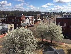
City square | |
 Location of Savannah, Tennessee | |
| Coordinates: 35°13′25″N 88°14′13″W / 35.22361°N 88.23694°WCoordinates: 35°13′25″N 88°14′13″W / 35.22361°N 88.23694°W | |
| Country | United States |
| State | Tennessee |
| County | Hardin |
| Settled | 1820s[1] |
| Incorporated | 1833[2] |
| Named for | Savannah, Georgia[1] |
| Area | |
| • Total | 5.7 sq mi (14.8 km2) |
| • Land | 5.7 sq mi (14.8 km2) |
| • Water | 0.0 sq mi (0.0 km2) |
| Elevation | 443 ft (135 m) |
| Population (2000) | |
| • Total | 6,917 |
| • Density | 1,207.5/sq mi (466.2/km2) |
| Time zone | Central (CST) (UTC-6) |
| • Summer (DST) | CDT (UTC-5) |
| ZIP code | 38372 |
| Area code(s) | 731 |
| FIPS code | 47-66720[3] |
| GNIS feature ID | 1300820[4] |
| Website | cityofsavannah.org |
Savannah is a city in and the county seat of Hardin County, Tennessee, United States.[5] The population was 6,917 at the 2000 census.
Savannah hosted the NAIA college football national championship game from 1996-2007, and is home to several places of historical significance, including the Cherry Family Mansion and apparently the resting place of the "22nd official(ly) Certified Mainstreet Community" in Tennessee.[6]
History
The city's original name was Rudd's Ferry, named for James Rudd, an early settler who established a ferry at the site in the early 1820s. Rudd's Ferry was later purchased by a wealthy landowner, David Robinson. The city was renamed "Savannah" after Savannah, Georgia, the hometown of Rudd's wife, Elizabeth.[1]
Battle of Shiloh
Hardin County was the site of the 1862 Battle of Shiloh (also known as the "Battle of Pittsburg Landing") during the Civil War. This battleground site is just south of the city of Savannah. Union General Ulysses S. Grant commandeered the Cherry Mansion just off the city square for use as a headquarters during the battle.
Pickwick Landing State Park
Just outside Savannah lies Pickwick Landing State Park. Originally a steamboat stop, the Tennessee Valley Authority bought the site in the 1930s during the Great Depression and a constructed a dam so electricity could be a generated. In 1969, Tennessee bought 681 acres (276 ha) from the TVA and made it a state park.[7]
Geography
Savannah is located at 35°13′25″N 88°14′13″W / 35.22361°N 88.23694°W (35.223674, -88.237011).[8]
According to the United States Census Bureau, the city has a total area of 5.7 square miles (15 km2), (This does not account for the number of people who live in the countryside).
Demographics
| Historical population | |||
|---|---|---|---|
| Census | Pop. | %± | |
| 1850 | 466 | — | |
| 1870 | 328 | — | |
| 1880 | 1,006 | 206.7% | |
| 1890 | 1,087 | 8.1% | |
| 1920 | 758 | — | |
| 1930 | 1,129 | 48.9% | |
| 1940 | 1,504 | 33.2% | |
| 1950 | 1,698 | 12.9% | |
| 1960 | 4,315 | 154.1% | |
| 1970 | 5,576 | 29.2% | |
| 1980 | 6,992 | 25.4% | |
| 1990 | 6,547 | −6.4% | |
| 2000 | 6,917 | 5.7% | |
| 2010 | 6,982 | 0.9% | |
| Est. 2015 | 7,027 | [9] | 0.6% |
| Sources:[10][11] | |||

As of the census[3] of 2000, there were 6,917 people, 2,915 households, and 1,862 families residing in the city. The population density was 1,207.5 people per square mile (466.1/km²). There were 3,206 housing units at an average density of 559.7 per square mile (216.0/km²). The racial makeup of the city was 89.79% White, 8.56% African American, 0.22% Native American, 0.29% Asian, 0.01% Pacific Islander, 0.35% from other races, and 0.78% from two or more races. Hispanic or Latino of any race were 1.13% of the population.
There were 2,915 households out of which 27.9% had children under the age of 18 living with them, 45.3% were married couples living together, 15.0% had a female householder with no husband present, and 36.1% were non-families. 32.8% of all households were made up of individuals and 15.8% had someone living alone who was 65 years of age or older. The average household size was 2.25 and the average family size was 2.83.
In the city the population was spread out with 22.4% under the age of 18, 8.6% from 18 to 24, 24.3% from 25 to 44, 24.0% from 45 to 64, and 20.7% who were 65 years of age or older. The median age was 41 years. For every 100 females there were 85.3 males. For every 100 females age 18 and over, there were 79.7 males.
The median income for a household in the city was $22,779, and the median income for a family was $29,771. Males had a median income of $26,311 versus $20,219 for females. The per capita income for the city was $15,101. About 20.7% of families and 23.9% of the population were below the poverty line, including 28.4% of those under age 18 and 16.5% of those age 65 or over.
Notable people
- John Barnhill, American football player, coach, and collegiate athletics administrator
- Stubby Clapp, Minor League baseball player
- Geron Davis, musician and composer
- Hank DeBerry, Major League baseball catcher in the early 20th century
- Bolden Reush Harrison, Naval officer and Medal of Honor recipient
- Jim Hardin, Major League pitcher from 1967-1973, World Series Champion in 1970.
- Chad Harville, Major League pitcher
- Granville Hinton, politician
- Myles Horton, educator and civil rights activist.
- Elizabeth Patterson, actress on I Love Lucy
- Herman L. Wolfe, Sr., politician
- Darryl Worley, country music performer
- Larry A Griffin, National Guard Soldier
References
- 1 2 3 The History of Cherry Mansion, 12 January 2011. Retrieved: 4 February 2013.
- ↑ Tennessee Blue Book, 2005-2006, pp. 618-625.
- 1 2 "American FactFinder". United States Census Bureau. Retrieved 2008-01-31.
- ↑ "US Board on Geographic Names". United States Geological Survey. 2007-10-25. Retrieved 2008-01-31.
- ↑ "Find a County". National Association of Counties. Retrieved 2011-06-07.
- ↑ "cityofsavannah.org - Mainstreet". cityofsavannah.org. Retrieved 2016-01-10.
- ↑ "Pickwick Landing State Park". tnstateparks.com. Retrieved 2016-01-29.
- ↑ "US Gazetteer files: 2010, 2000, and 1990". United States Census Bureau. 2011-02-12. Retrieved 2011-04-23.
- ↑ "Annual Estimates of the Resident Population for Incorporated Places: April 1, 2010 to July 1, 2015". Retrieved July 2, 2016.
- ↑ "Census of Population and Housing: Decennial Censuses". United States Census Bureau. Retrieved 2012-03-04.
- ↑ "Incorporated Places and Minor Civil Divisions Datasets: Subcounty Resident Population Estimates: April 1, 2010 to July 1, 2012". Population Estimates. U.S. Census Bureau. Retrieved 11 December 2013.
External links
Municipalities and communities of Hardin County, Tennessee, United States | ||
|---|---|---|
| Cities | ||
| Towns | ||
| CDPs | ||
| Unincorporated communities |
| |
| Footnotes | ‡This populated place also has portions in an adjacent county or counties | |