Sargent, Nebraska
| Sargent, Nebraska | |
|---|---|
| City | |
|
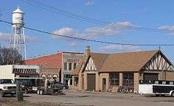
Downtown Sargent | |
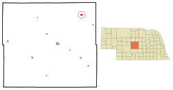 Location of Sargent, Nebraska | |
| Coordinates: 41°38′27″N 99°22′18″W / 41.64083°N 99.37167°WCoordinates: 41°38′27″N 99°22′18″W / 41.64083°N 99.37167°W | |
| Country | United States |
| State | Nebraska |
| County | Custer |
| Area[1] | |
| • Total | 1.07 sq mi (2.77 km2) |
| • Land | 1.07 sq mi (2.77 km2) |
| • Water | 0 sq mi (0 km2) |
| Elevation | 2,316 ft (706 m) |
| Population (2010)[2] | |
| • Total | 525 |
| • Estimate (2012[3]) | 513 |
| • Density | 490.7/sq mi (189.5/km2) |
| Time zone | Central (CST) (UTC-6) |
| • Summer (DST) | CDT (UTC-5) |
| ZIP code | 68874 |
| Area code(s) | 308 |
| FIPS code | 31-43685 |
| GNIS feature ID | 0833223[4] |
Sargent is a city in Custer County, Nebraska, United States. The population was 525 at the 2010 census. The name was chosen by an early postal official to honor close friends.
History
Sargent was laid out in 1883.[5] It was named for George D. Sargent, a railroad official.[6] The town experienced rapid growth when the railroad extended to it in 1899.[7]
Geography
Sargent is located at 41°38′27″N 99°22′18″W / 41.64083°N 99.37167°W (41.640950, -99.371788).[8]
According to the United States Census Bureau, the city has a total area of 1.07 square miles (2.77 km2), all of it land.[1]
Sargent is located on US Route 183 (Ord Street) and is close to the geographic center of Nebraska. It is next to the Middle Loup River.
Demographics
| Historical population | |||
|---|---|---|---|
| Census | Pop. | %± | |
| 1900 | 250 | — | |
| 1910 | 651 | 160.4% | |
| 1920 | 1,078 | 65.6% | |
| 1930 | 834 | −22.6% | |
| 1940 | 847 | 1.6% | |
| 1950 | 818 | −3.4% | |
| 1960 | 876 | 7.1% | |
| 1970 | 789 | −9.9% | |
| 1980 | 828 | 4.9% | |
| 1990 | 710 | −14.3% | |
| 2000 | 649 | −8.6% | |
| 2010 | 525 | −19.1% | |
| Est. 2015 | 509 | [9] | −3.0% |
| U.S. Decennial Census[10] 2012 Estimate[11] | |||
2010 census
As of the census[2] of 2010, there were 525 people, 245 households, and 148 families residing in the city. The population density was 490.7 inhabitants per square mile (189.5/km2). There were 318 housing units at an average density of 297.2 per square mile (114.7/km2). The racial makeup of the city was 99.0% White, 0.6% African American, 0.2% Asian, and 0.2% from two or more races. Hispanic or Latino of any race were 1.5% of the population.
There were 245 households of which 25.7% had children under the age of 18 living with them, 48.2% were married couples living together, 8.6% had a female householder with no husband present, 3.7% had a male householder with no wife present, and 39.6% were non-families. 36.3% of all households were made up of individuals and 20% had someone living alone who was 65 years of age or older. The average household size was 2.14 and the average family size was 2.76.
The median age in the city was 47.6 years. 22.9% of residents were under the age of 18; 6.5% were between the ages of 18 and 24; 17.2% were from 25 to 44; 28.5% were from 45 to 64; and 25% were 65 years of age or older. The gender makeup of the city was 50.1% male and 49.9% female.
2000 census
As of the census of 2000, there were 649 people, 279 households, and 174 families residing in the city. The population density was 730.3 people per square mile (281.6/km²). There were 341 housing units at an average density of 383.7 per square mile (147.9/km²). The racial makeup of the city was 97.84% White, 0.77% Native American, 0.31% Asian, 0.77% from other races, and 0.31% from two or more races. Hispanic or Latino of any race were 2.16% of the population.
There were 279 households out of which 23.3% had children under the age of 18 living with them, 53.0% were married couples living together, 7.9% had a female householder with no husband present, and 37.6% were non-families. 37.6% of all households were made up of individuals and 22.9% had someone living alone who was 65 years of age or older. The average household size was 2.18 and the average family size was 2.83.
In the city the population was spread out with 23.0% under the age of 18, 4.6% from 18 to 24, 20.2% from 25 to 44, 21.1% from 45 to 64, and 31.1% who were 65 years of age or older. The median age was 47 years. For every 100 females there were 88.1 males. For every 100 females age 18 and over, there were 79.9 males.
As of 2000 the median income for a household in the city was $24,559, and the median income for a family was $30,714. Males had a median income of $24,135 versus $21,750 for females. The per capita income for the city was $13,962. About 16.1% of families and 16.3% of the population were below the poverty line, including 23.3% of those under age 18 and 7.4% of those age 65 or over.
References
- 1 2 "US Gazetteer files 2010". United States Census Bureau. Retrieved 2012-06-24.
- 1 2 "American FactFinder". United States Census Bureau. Retrieved 2012-06-24.
- ↑ "Population Estimates". United States Census Bureau. Retrieved 2013-05-29.
- ↑ "US Board on Geographic Names". United States Geological Survey. 2007-10-25. Retrieved 2008-01-31.
- ↑ Burr, George L. (1921). History of Hamilton and Clay Counties, Nebraska, Volume 1. S.J. Clarke Publishing Company. p. 106.
- ↑ "Profile for Sargent, NE". Epodunk. Retrieved 6 August 2014.
- ↑ Butcher, Solomon Devore (1901). S.D. Butcher's Pioneer History of Custer County: And Short Sketches of Early Days in Nebraska. Merchants Publishing Company. p. 296.
- ↑ "US Gazetteer files: 2010, 2000, and 1990". United States Census Bureau. 2011-02-12. Retrieved 2011-04-23.
- ↑ "Annual Estimates of the Resident Population for Incorporated Places: April 1, 2010 to July 1, 2015". Retrieved July 2, 2016.
- ↑ United States Census Bureau. "Census of Population and Housing". Retrieved October 18, 2013.
- ↑ "Annual Estimates of the Resident Population: April 1, 2010 to July 1, 2012". Retrieved October 18, 2013.
External links
Municipalities and communities of Custer County, Nebraska, United States | ||
|---|---|---|
| Cities | ||
| Villages | ||
| Townships | ||
| CDP | ||
| Unincorporated communities | ||
| Ghost towns | ||