Sapad, Lanao del Norte
| Sapad | |
|---|---|
| Municipality | |
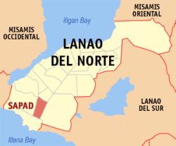 Map of Lanao del Norte with Sapad highlighted | |
.svg.png) Sapad Location within the Philippines | |
| Coordinates: 07°51′N 123°50′E / 7.850°N 123.833°ECoordinates: 07°51′N 123°50′E / 7.850°N 123.833°E | |
| Country | Philippines |
| Region | Northern Mindanao (Region X) |
| Province | Lanao del Norte |
| District | 2nd district of Lanao del Norte |
| Founded | June 21, 1969 |
| Barangays | 17 |
| Government[1] | |
| • Mayor | Paruk U. Asis |
| • Vice-Mayor | Hipolito S. Sienes |
| Area[2] | |
| • Total | 140.03 km2 (54.07 sq mi) |
| Population (2010)[3] | |
| • Total | 19,479 |
| • Density | 140/km2 (360/sq mi) |
| Time zone | PST (UTC+8) |
| ZIP code | 9213 |
| Dialing code | +63 (0)63 |
| Income class | 5th |
Sapad is a fifth class municipality in the province of Lanao del Norte, Philippines. According to the 2010 census, it has a population of 19,479 people.[3]
Barangays
Sapad is politically subdivided into 17 barangays.[2]
- Baning
- Poblacion Sapad (formerly Buriasan)
- Dansalan
- Gamal
- Inudaran I
- Inudaran II
- Karkum
- Katipunan
- Mabugnao
- Maito Salug
- Mala Salug
- Mama-anon
- Mapurog
- Pancilan
- Panoloon
- Pili
- Lower Sapad
Demographics
| Population census of Sapad | ||
|---|---|---|
| Year | Pop. | ±% p.a. |
| 1990 | 13,576 | — |
| 1995 | 14,595 | +1.37% |
| 2000 | 15,167 | +0.83% |
| 2007 | 17,191 | +1.74% |
| 2010 | 19,479 | +4.65% |
| Source: National Statistics Office[3] | ||
References
- ↑ "Official City/Municipal 2013 Election Results". Intramuros, Manila, Philippines: Commission on Elections (COMELEC). 1 July 2013. Retrieved 5 September 2013.
- 1 2 "Province: LANAO DEL NORTE". PSGC Interactive. Makati City, Philippines: National Statistical Coordination Board. Retrieved 7 July 2014.
- 1 2 3 "Total Population by Province, City, Municipality and Barangay: as of May 1, 2010" (PDF). 2010 Census of Population and Housing. National Statistics Office. Retrieved 7 July 2014.
External links
- Philippine Standard Geographic Code
- Philippine Census Information
- Local Governance Performance Management System
 |
Lala | Salvador | | |
| Kapatagan | |
Nunungan | ||
| ||||
| | ||||
| Sultan Naga Dimaporo |
Tubod (capital) | |
| Municipalities | |
| Highly urbanized city |
|
This article is issued from Wikipedia - version of the 11/1/2016. The text is available under the Creative Commons Attribution/Share Alike but additional terms may apply for the media files.