Sandston, Virginia
| Sandston, Virginia | |
|---|---|
| Census-designated place | |
 Sandston, Virginia Location within the commonwealth of Virginia | |
| Coordinates: 37°31′25″N 77°18′57″W / 37.52361°N 77.31583°WCoordinates: 37°31′25″N 77°18′57″W / 37.52361°N 77.31583°W | |
| Country |
|
| State |
|
| County |
|
| Area | |
| • Total | 10.0 sq mi (25.8 km2) |
| • Land | 9.9 sq mi (25.6 km2) |
| • Water | 0.08 sq mi (0.2 km2) |
| Population (2010) | |
| • Total | 7,571 |
| • Density | 760/sq mi (290/km2) |
| Time zone | Eastern (EST) (UTC−5) |
| • Summer (DST) | EDT (UTC−4) |
| ZIP code | 23150 |
Sandston is a census-designated place (CDP) in Henrico County, Virginia, United States, just outside the state capital of Richmond. The population as of the 2010 Census was 7,571.
History
During World War I, a number of homes were built in the area for both non-commissioned officers and enlisted men. After the war, an investment group headed by Oliver J. Sands bought the land and buildings as surplus property. The community was named Sandston after Oliver Sands, the president of the Richmond and Fairfield Railway, the electric street railway line which ran through Highland Springs and Fair Oaks to the National Cemetery at Seven Pines.
The community was later served by the Fairfield Transit Company, which operated a bus barn extant at Seven Pines in 2005 and the earlier trolley car barn in Richmond on North 29th Street. The road from Richmond, through Highland Springs, to Seven Pines was named "Nine Mile Road" because of the distance of the streetcar/trolley line.
References
Municipalities and communities of Henrico County, Virginia, United States | ||
|---|---|---|
| CDPs | 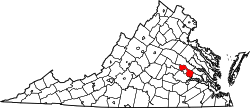 | |
| Unincorporated communities | ||