San Jacinto High School (Houston, Texas)

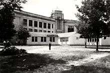
San Jacinto High School was a secondary school located at 1300 Holman Street in Houston, Texas; now part of the Houston Community College Central College, Central Campus. San Jacinto High School was located in the area now known as Midtown.
History
The school was established in 1926 after Central High School, which was located near Downtown Houston, was closed. From 1927 until 1934, the campus was also the first home to Houston Junior College, which eventually became the University of Houston.
Lamar High School opened in 1937, relieving San Jacinto.[1]
In 1962 a technical program was added to the campus. In 1966 HISD purchased a former Hebrew temple,[2] Temple Beth Israel,[3] that it began using as an annex for San Jacinto since its population was increasing. Elaine Clift Gore, the author of Talent Knows No Color: The History of an Arts Magnet High School, wrote that by fall 1969 San Jacinto's vocational program became "the premier HISD vocational high school".[2]
The school was renamed the Houston Technical Institute on June 1, 1971.[3] The neighborhood program ended in 1971, and the technical program was abolished in 1985. High School for the Performing and Visual Arts was housed at San Jacinto from 1971 to 1981. Houston Community College System purchased the school grounds. The San Jacinto Memorial Museum is on the school grounds.
In 2014, Skanska USA Building completed $35 million in work to update and restore the San Jacinto Memorial Building, which was originally built in phases between 1914 and 1936. Hidden, original windows were encountered during the demolition and restored/left in place as a design element. Other new elements were introduced including six 5,000-pound beams that have been installed to enable modern, column-free bathrooms, and an elevator tower, and four stair towers added to the rear of the building. In the auditorium, seating, plaster, and flooring were redone as well.
Demographics
In the northern hemisphere fall of 1969, 51.6% of San Jacinto's students were black and 48.4% were White. The figure for White students included non-Hispanic white students and Hispanics together. For several years prior to the 1970 desegregation, HISD had a policy stating that if a student wanted to take a vocational program not at his or her zoned school, he or she could transfer to another school that offered that program whether it was a "white" school or a "black" school.[2]
In 1940 there were five students of Mexican origin enrolled at San Jacinto.[4]
Notable alumni
- Dr. Denton Cooley, heart surgeon [5][6][7]
- Walter Cronkite (1933), television journalist[7]
- Albert Bel Fay (1930), Houston businessman and Republican party activist
- A. J. Foyt, Jr., auto racer (also attended Pershing and Hamilton middle schools and Lamar High School - did not graduate from San Jacinto)[7]
- James E. Lyon, Houston developer and Republican politician[8]
- Glenn McCarthy, oilman and entrepreneur[7]
- Maxine Mesinger, gossip columnist[9]
- Diane Ravitch, former US Assistant Secretary of Education, author, historian
- Jack Witte, former Chairman, First State Bank of Bellaire
- David Westheimer, author[7]
- Kathy Whitmire,[7] former Mayor of Houston
- Gale Storm (born Josephine Cottle), actress, singer[10]
See also
References
- Gore, Elaine Clift. Talent Knows No Color: The History of an Arts Magnet High School (Research in curriculum and instruction) Information Age Publishing, 2007. ISBN 1593117612, 9781593117610.
Notes
- ↑ Becker, Ann Dunphy and George Murray. Houston's River Oaks. Arcadia Publishing, April 29, 2013. p. 43. ISBN 1439642362, 9781439642368.
- 1 2 3 Gore, p. 8.
- 1 2 Gore, p. 10.
- ↑ San Miguel, Guadalupe. Brown, Not White: School Integration and the Chicano Movement in Houston (Volume 3 of University of Houston Series in Mexican American Studies, Sponsored by the Center for Mexican American Studies). Texas A&M University Press, October 26, 2005. ISBN 1585444936, 9781585444939. CITED: p. 219.
- ↑ "UT-Austin Names New Sports Arena in Honor of Dr. Denton A. Cooley." Texas Medical Center. Retrieved on June 30, 2009.
- ↑ "Proud Products of Texas Public Schools." Texas Association of School Boards. Retrieved on June 30, 2009.
- 1 2 3 4 5 6 "Distinguished HISD Alumni," Houston Independent School District. Retrieved on June 30, 2009.
- ↑ "Rites Set for Developer, Banker James E. Lyon", Houston Chronicle, May 2, 1993
- ↑ "Maxine Mesinger Papers, 1965-2001." University of Houston. Retrieved on November 20, 2011.
- ↑ O'Hare, Peggy. "Houston's Storm led American Idol life in '30s Margie star who died at 87 won U.S. talent competition here." Tuesday June 30, 2009. B3. Retrieved on July 23, 2009.
Coordinates: 29°44′15″N 95°22′36″W / 29.737412°N 95.376577°W