Salt Flat, Texas
| Salt Flat | |
|---|---|
| ghost town | |
|
Salt Flat | |
 Salt Flat  Salt Flat Location within the state of Texas | |
| Coordinates: 31°44′37″N 105°5′34″W / 31.74361°N 105.09278°WCoordinates: 31°44′37″N 105°5′34″W / 31.74361°N 105.09278°W | |
| Country | United States |
| State | Texas |
| County | F |
| Elevation | 3,730 ft (1,140 m) |
| Time zone | Mountain (CST) (UTC-7) |
| • Summer (DST) | MDT (UTC-6) |
| ZIP codes | 79847 |
| GNIS feature ID | 1367427 |
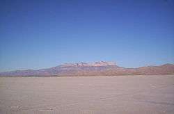
Salt Flat is a ghost town in northeastern Hudspeth County, Texas, United States. It lies along the concurrent U.S. Routes 62 and 180 north of the Census-designated place (CDP) of Sierra Blanca, the county seat of Hudspeth County.[1] Its elevation is 3,730 feet (1,137 m).[2] Although Salt Flat is unincorporated, it has a ZIP code of 79847.[3] The headquarters of the nearby Guadalupe Mountains National Park uses this ZIP Code although it is located closer to Pine Springs, which has no post office.
Salt deposits
Just outside the community there is a dry salt pan. The San Elizario Salt War was a dispute over ownership and access to these salt deposits.[4]
References
- ↑ Rand McNally. The Road Atlas '08. Chicago: Rand McNally, 2008, p. 99.
- ↑ U.S. Geological Survey Geographic Names Information System: Salt Flat, Texas
- ↑ Zip Code Lookup
- ↑ The Salt War of San Elizaro, The Handbook of Texas Online
External links
- Kohout, Martin Donell. Salt Flat, TX, Handbook of Texas Online (accessed December 22, 2012)
- Guadalupe Mountains NP (Official Site) (accessed December 22, 2012)
Municipalities and communities of Hudspeth County, Texas, United States | ||
|---|---|---|
| City | 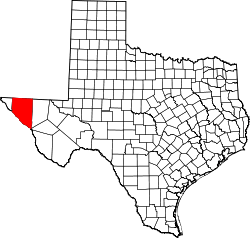 | |
| CDPs | ||
| Unincorporated communities | ||
| Ghost towns | ||
This article is issued from Wikipedia - version of the 9/11/2016. The text is available under the Creative Commons Attribution/Share Alike but additional terms may apply for the media files.