Saint-Vérain
| Saint-Vérain | ||
|---|---|---|
|
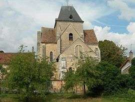
The church in Saint-Vérain | ||
| ||
 Saint-Vérain | ||
|
Location within Bourgogne-Franche-Comté region  Saint-Vérain | ||
| Coordinates: 47°28′54″N 3°03′24″E / 47.4817°N 3.0567°ECoordinates: 47°28′54″N 3°03′24″E / 47.4817°N 3.0567°E | ||
| Country | France | |
| Region | Bourgogne-Franche-Comté | |
| Department | Nièvre | |
| Arrondissement | Cosne-Cours-sur-Loire | |
| Canton | Saint-Amand-en-Puisaye | |
| Intercommunality | Puisaye Nivernaise | |
| Government | ||
| • Mayor (2001–2008) | Jean-Luc Chevalier | |
| Area1 | 24.69 km2 (9.53 sq mi) | |
| Population (2006)2 | 387 | |
| • Density | 16/km2 (41/sq mi) | |
| Time zone | CET (UTC+1) | |
| • Summer (DST) | CEST (UTC+2) | |
| INSEE/Postal code | 58270 / 58310 | |
| Elevation | 184–312 m (604–1,024 ft) | |
|
1 French Land Register data, which excludes lakes, ponds, glaciers > 1 km² (0.386 sq mi or 247 acres) and river estuaries. 2 Population without double counting: residents of multiple communes (e.g., students and military personnel) only counted once. | ||
.svg.png)
Saint-Vérain is a commune in the Nièvre department in central France.
See also
References
| Wikimedia Commons has media related to Saint-Vérain. |
This article is issued from Wikipedia - version of the 3/14/2015. The text is available under the Creative Commons Attribution/Share Alike but additional terms may apply for the media files.