Saint-Sauvant, Vienne
| Saint-Sauvant | |
|---|---|
|
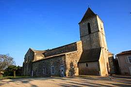
The church in Saint-Sauvant | |
 Saint-Sauvant | |
|
Location within Nouvelle-Aquitaine region  Saint-Sauvant | |
| Coordinates: 46°21′37″N 0°03′25″E / 46.3603°N 0.0569°ECoordinates: 46°21′37″N 0°03′25″E / 46.3603°N 0.0569°E | |
| Country | France |
| Region | Nouvelle-Aquitaine |
| Department | Vienne |
| Arrondissement | Poitiers |
| Canton | Lusignan |
| Intercommunality | Pays Mélusin |
| Government | |
| • Mayor (2008–2014) | Marc Menneteau |
| Area1 | 59.58 km2 (23.00 sq mi) |
| Population (2006)2 | 1,330 |
| • Density | 22/km2 (58/sq mi) |
| Time zone | CET (UTC+1) |
| • Summer (DST) | CEST (UTC+2) |
| INSEE/Postal code | 86244 / 86600 |
| Elevation | 122–159 m (400–522 ft) |
|
1 French Land Register data, which excludes lakes, ponds, glaciers > 1 km² (0.386 sq mi or 247 acres) and river estuaries. 2 Population without double counting: residents of multiple communes (e.g., students and military personnel) only counted once. | |
Saint-Sauvant is a commune in the Vienne department in the Nouvelle-Aquitaine region in western France.
See also
References
| Wikimedia Commons has media related to Saint-Sauvant (Vienne). |
This article is issued from Wikipedia - version of the 11/11/2016. The text is available under the Creative Commons Attribution/Share Alike but additional terms may apply for the media files.