Saint-Hippolyte-le-Graveyron
| Saint-Hippolyte-le-Graveyron | ||
|---|---|---|
|
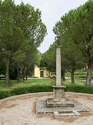
Column with a cross at the centre of the village | ||
| ||
 Saint-Hippolyte-le-Graveyron | ||
|
Location within Provence-A.-C.d'A. region  Saint-Hippolyte-le-Graveyron | ||
| Coordinates: 44°07′25″N 5°04′30″E / 44.1236°N 5.075°ECoordinates: 44°07′25″N 5°04′30″E / 44.1236°N 5.075°E | ||
| Country | France | |
| Region | Provence-Alpes-Côte d'Azur | |
| Department | Vaucluse | |
| Arrondissement | Carpentras | |
| Canton | Carpentras-Nord | |
| Intercommunality | Ventoux-Comtat Venaissin | |
| Area1 | 4.94 km2 (1.91 sq mi) | |
| Population (2006)2 | 169 | |
| • Density | 34/km2 (89/sq mi) | |
| Time zone | CET (UTC+1) | |
| • Summer (DST) | CEST (UTC+2) | |
| INSEE/Postal code | 84109 / 84330 | |
| Elevation |
135–438 m (443–1,437 ft) (avg. 170 m or 560 ft) | |
|
1 French Land Register data, which excludes lakes, ponds, glaciers > 1 km² (0.386 sq mi or 247 acres) and river estuaries. 2 Population without double counting: residents of multiple communes (e.g., students and military personnel) only counted once. | ||
.svg.png)
Saint-Hippolyte-le-Graveyron is a commune in the Vaucluse department in the Provence-Alpes-Côte d'Azur region in southeastern France.
Sites and Monuments
- Stone column topped by an iron cross.
- Chateau Juvenal 19th century
- Parish church, built in 1830, land donated by a former mayor Hypolite Fabre.
See also
References
| Wikimedia Commons has media related to Saint-Hippolyte-le-Graveyron. |
This article is issued from Wikipedia - version of the 2/18/2016. The text is available under the Creative Commons Attribution/Share Alike but additional terms may apply for the media files.