Saddleworth Moor
| Saddleworth Moor | |
|---|---|
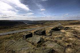 Saddleworth Moor towards Dovestone Reservoir | |
| Highest point | |
| Coordinates | 53°32′36″N 1°57′21″W / 53.54333°N 1.95583°WCoordinates: 53°32′36″N 1°57′21″W / 53.54333°N 1.95583°W |
| Geography | |
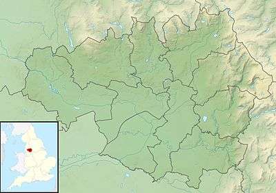 Saddleworth Moor Location of Saddleworth Moor in Greater Manchester | |
| Location | Northern England |
| Parent range | South Pennines |
| Geology | |
| Mountain type | Moorland |
| Climbing | |
| Easiest route | Pennine Way |
Saddleworth Moor is an area of the South Pennines in Northern England. It is within the Dark Peak area of the Peak District National Park. The land reaches over 1,312 feet (400 m) above sea level. It is crossed by the A635 road and the Pennine Way passes to its eastern side.[1][2]
Geography
The moor takes its name from the parish of Saddleworth to the west, historically a part of the West Riding of Yorkshire although on the western side of the Pennines, but a part of Greater Manchester since 1974. The moor, an elevated plateau with gritstone escarpments or edges and, around its margins, deeply incised v-shaped valleys or cloughs[lower-alpha 1] with fast-flowing streams, straddles the metropolitan boroughs of Oldham in Greater Manchester and Kirklees in West Yorkshire. Moorland east of the county boundary with West Yorkshire is known as Wessenden Moor and Wessenden Head Moor. The moor is crossed by the A635 between the Greater Manchester and West Yorkshire Urban Areas. The A635 is known locally as the Isle of Skye road and takes this name from a former public house at Wessenden Head that was demolished after a fire. The Pennine Way arrives from the Wessenden Valley to the north and crosses the moor on its ascent to Black Hill on Holme Moss to the south. The high moorland is sparsely inhabited. Scattered farmsteads, built of gritstone, and fields demarcated by dry stone walls are on the lower land and in the valleys where there is some coniferous woodland. The overlying peat is cut by drainage channels or groughs. Much of the area is open access land.[2]
Vegetation
Blanket bog in the area is the most south-easterly occurrence in Europe. Cottongrass is the most dominant feature and sphagnum mosses are scarce. Heather, crowberry, bilberry and the rare cloudberry are also found. There are extensive areas of bare peat from which the surface has eroded. The peat formation is 9,000 years old.[4]
Reservoirs
Dovestone, Yeoman Hey, Greenfield and Chew Reservoirs east of Oldham, are accessed from the A635 road. They supply water to the surrounding area. The valley is surrounded by rocky outcrops and moorland. Spruce and pine plantations are found in the valley and broad-leaved trees have been introduced to provide a more diverse habitat.[5]
Yeoman Hey was built in 1880 and Chew Reservoir in 1914, and when built, was the highest reservoir in the British Isles at 1,601 feet (488 m) above sea level. The bed of a tramway, built to aid its construction remains visible. The area around the reservoir is used for recreation.[5]
Events
In August 1949, a BEA Douglas DC3 crashed into the hill at Wimberry Stones at the top of the Chew Valley killing 24 passengers and crew and leaving 8 survivors.[6]
The moor became infamous as the burial site of four victims of Ian Brady and Myra Hindley, the Moors murderers. In October 1965 the bodies of Lesley Ann Downey and John Kilbride were discovered, having been buried there during the previous two years. John Kilbride was murdered on the moors by Brady in the absence of Hindley, while Lesley Ann Downey was murdered at the couple's house in nearby Hattersley before being buried on the moors. After finding other evidence elsewhere connecting Brady and Hindley to the missing two children, the police were led to Saddleworth Moor by photographs found among Brady's possessions, and claims by Hindley's brother-in-law David Smith that Brady had boasted of committing several murders and burying the bodies on Saddleworth Moor.
The body of Pauline Reade, their first victim in July 1963, was recovered on 1 July 1987, almost a year after Brady and Hindley admitted murdering her. They also admitted murdering Keith Bennett in June 1964, but his body has never been found. Brady had killed his fifth victim, Edward Evans, at his house in Hattersley, but was arrested before he had chance to dispose of it.[7]
In December 2015 the body of an unknown man was found beneath Rob’s Rocks on the track between Chew and Dovestone Reservoirs. He had died of strychnine poisoning and his identity remains a mystery.[8]
References
Notes
- ↑ Clough is derived from the Old English cloh which means a deep valley or ravine.[3]
Citations
- ↑ Peak District National Park, Peak District National Park Authority, retrieved 20 July 2012
- 1 2 Dark Peak (pdf), Natural England, p. 3, retrieved 20 July 2012
- ↑ Mills 1998, p. 402
- ↑ South Pennine Moors, Defra, retrieved 21 July 2012
- 1 2 Dove Stone Reservoir, United Utilities, retrieved 21 July 2012
- ↑ "Accident Description". Aviation Safety Network. Retrieved 15 June 2016.
- ↑ "20 November 1986: Police renew hunt for Moors victims". On this day 1950–2005. BBC. 2008.
- ↑ "Body on the Moor". BBC News. Retrieved 13 June 2016.
Bibliography
- Mills, A.D. (1998), A Dictionary of English Placenames, Oxford University Press, ISBN 0-19-280074-4
| Wikimedia Commons has media related to Saddleworth. |