Rutherford, Tennessee
| Rutherford, Tennessee | |
|---|---|
| Town | |
| Nickname(s): The Last Home of Davy Crockett | |
 Location of Rutherford, Tennessee | |
| Coordinates: 36°7′32″N 88°59′24″W / 36.12556°N 88.99000°WCoordinates: 36°7′32″N 88°59′24″W / 36.12556°N 88.99000°W | |
| Country | United States |
| State | Tennessee |
| County | Gibson |
| Government | |
| • Mayor | Keith Cardwell |
| Area | |
| • Total | 2.3 sq mi (5.9 km2) |
| • Land | 2.3 sq mi (5.8 km2) |
| • Water | 0.0 sq mi (0.0 km2) |
| Elevation | 331 ft (101 m) |
| Population (2010) | |
| • Total | 1,151 |
| • Density | 565.1/sq mi (218.2/km2) |
| Time zone | Central (CST) (UTC-6) |
| • Summer (DST) | CDT (UTC-5) |
| ZIP code | 38369 |
| Area code(s) | 731 |
| FIPS code | 47-65760[1] |
| GNIS feature ID | 1300352[2] |
| Website | http://www.townofrutherford.org/ |
Rutherford is a town in Gibson County, Tennessee. At the 2000 census, its population was at 1,272 and in 2010 the population was 1,151.
Geography
Rutherford is located at 36°07′32″N 88°59′24″W / 36.125689°N 88.990051°W.[3]
According to the United States Census Bureau, the town has a total area of 2.3 square miles (6.0 km2), of which 2.2 square miles (5.7 km2) is land and 0.44% is water.
Demographics
| Historical population | |||
|---|---|---|---|
| Census | Pop. | %± | |
| 1880 | 323 | — | |
| 1890 | 536 | 65.9% | |
| 1900 | 677 | 26.3% | |
| 1910 | 766 | 13.1% | |
| 1920 | 792 | 3.4% | |
| 1930 | 747 | −5.7% | |
| 1940 | 771 | 3.2% | |
| 1950 | 994 | 28.9% | |
| 1960 | 983 | −1.1% | |
| 1970 | 1,385 | 40.9% | |
| 1980 | 1,378 | −0.5% | |
| 1990 | 1,303 | −5.4% | |
| 2000 | 1,272 | −2.4% | |
| 2010 | 1,151 | −9.5% | |
| Est. 2015 | 1,109 | [4] | −3.6% |
| Sources:[5][6] | |||
As of the census[1] of 2000, there were 1,272 people, 542 households, and 365 families residing in the town. The population density was 565.1 people per square mile (218.3/km2). There were 589 housing units at an average density of 261.7 per square mile (101.1/km2). The racial makeup of the town was 77.91% White, 21.23% African American, 0.08% Native American, and 0.79% from two or more races. Hispanic or Latino of any race were 0.63% of the population.
There were 542 households out of which 27.3% had children under the age of 18 living with them, 46.3% were married couples living together, 16.8% had a female householder with no husband present, and 32.5% were non-families. 31.2% of all households were made up of individuals and 18.8% had someone living alone who was 65 years of age or older. The average household size was 2.35 and the average family size was 2.91.
In the town the population was spread out with 23.7% under the age of 18, 6.6% from 18 to 24, 25.9% from 25 to 44, 23.7% from 45 to 64, and 20.1% who were 65 years of age or older. The median age was 40 years. For every 100 females there were 78.9 males. For every 100 females age 18 and over, there were 77.7 males.
The median income for a household in the town was $29,954, and the median income for a family was $37,656. Males had a median income of $27,143 versus $17,093 for females. The per capita income for the town was $15,311. About 10.4% of families and 13.6% of the population were below the poverty line, including 14.4% of those under age 18 and 13.7% of those age 65 or over.
Attractions and history
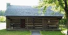
Rutherford promotes itself as the "Last Home of Davy Crockett". Crockett's reconstructed cabin is located in downtown Rutherford as is the grave of his mother. Rutherford hosts a community festival called "Davy Crockett Days" each year. Past grand marshals of the Davy Crockett Days Parade include Fess Parker who portrayed Davy Crockett in the 1954 Walt Disney television series Ballad of Davy Crockett.
Media
Radio Stations
- WWKF-FM 99.3 "Today's Best Music with Ace & TJ in the Morning"
- WENK-AM 1240 "The Greatest Hits of All Time"
- WTPR-AM 710 "The Greatest Hits of All Time"
- VICTORY937 WTKB-FM 93.7 "The Victory 93.7 Contemporary Christian"
References
- 1 2 "American FactFinder". United States Census Bureau. Retrieved 2008-01-31.
- ↑ "US Board on Geographic Names". United States Geological Survey. 2007-10-25. Retrieved 2008-01-31.
- ↑ "US Gazetteer files: 2010, 2000, and 1990". United States Census Bureau. 2011-02-12. Retrieved 2011-04-23.
- ↑ "Annual Estimates of the Resident Population for Incorporated Places: April 1, 2010 to July 1, 2015". Retrieved July 2, 2016.
- ↑ "Census of Population and Housing: Decennial Censuses". United States Census Bureau. Retrieved 2012-03-04.
- ↑ "Incorporated Places and Minor Civil Divisions Datasets: Subcounty Resident Population Estimates: April 1, 2010 to July 1, 2012". Population Estimates. U.S. Census Bureau. Retrieved 11 December 2013.
External links
| Wikimedia Commons has media related to Rutherford, Tennessee. |
- Town of Rutherford (Official Website)
Municipalities and communities of Gibson County, Tennessee, United States | ||
|---|---|---|
| Cities | ||
| Towns | ||
| Unincorporated communities | ||
| Footnotes | ‡This populated place also has portions in an adjacent county or counties | |