Rural Township, Jefferson County, Kansas
| Rural Township | |
|---|---|
| Township | |
|
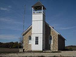
Buck Creek School east of Williamstown | |
 Location in Jefferson County | |
| Coordinates: 39°05′45″N 95°17′56″W / 39.09583°N 95.29889°WCoordinates: 39°05′45″N 95°17′56″W / 39.09583°N 95.29889°W | |
| Country | United States |
| State | Kansas |
| County | Jefferson |
| Area | |
| • Total | 32.19 sq mi (83.37 km2) |
| • Land | 31.82 sq mi (82.42 km2) |
| • Water | 0.37 sq mi (0.95 km2) 1.14% |
| Elevation | 1,047 ft (319 m) |
| Population (2000) | |
| • Total | 804 |
| • Density | 25.3/sq mi (9.8/km2) |
| GNIS feature ID | 0478497 |
Rural Township is a township in Jefferson County, Kansas, USA. It was formed in 1871, from the territory of Kentucky Township and Sarcoxie Township.[1] As of the 2000 census, its population was 804.
Geography
Rural Township covers an area of 32.19 square miles (83.37 square kilometers); of this, 0.37 square miles (0.95 square kilometers) or 1.14 percent is water. The streams of Buck Creek, East Stone House Creek, Stone Horse Creek and West Stone House Creek run through this township.
Unincorporated towns
(This list is based on USGS data and may include former settlements.)
Adjacent townships
- Oskaloosa Township (north)
- Sarcoxie Township (east)
- Grant Township, Douglas County (southeast)
- Wakarusa Township, Douglas County (south)
- Lecompton Township, Douglas County (southwest)
- Kentucky Township (west)
Cemeteries
The township contains three cemeteries: Buster, Holliday and Underwood.
Major highways
- U.S. Route 24
- U.S. Route 24, 59
- U.S. Route 59
References
- ↑ Cutler, William G. (1883). Cutler's History of The State of Kansas. Chicago, IL: A. T. Andreas.
External links
Municipalities and communities of Jefferson County, Kansas, United States | ||
|---|---|---|
| Cities | 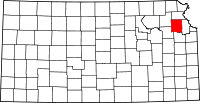 | |
| CDP | ||
| Unincorporated communities | ||
| Townships | ||
This article is issued from Wikipedia - version of the 11/11/2013. The text is available under the Creative Commons Attribution/Share Alike but additional terms may apply for the media files.