Royal Lakes, Illinois
| Royal Lakes | |
| Village | |
| Country | United States |
|---|---|
| State | Illinois |
| County | Macoupin |
| Township | Hillyard |
| Elevation | 640 ft (195 m) |
| Coordinates | 39°6′42″N 89°57′38″W / 39.11167°N 89.96056°WCoordinates: 39°6′42″N 89°57′38″W / 39.11167°N 89.96056°W |
| Area | 0.51 sq mi (1 km2) |
| - land | 0.47 sq mi (1 km2) |
| - water | 0.05 sq mi (0 km2) |
| Population | 190 (2000) |
| Density | 408.1/sq mi (158/km2) |
| Timezone | CST (UTC-6) |
| - summer (DST) | CDT (UTC-5) |
| Postal code | 62685 |
| Area code | 618 |
  Location of Royal Lakes within Illinois | |
| Wikimedia Commons: Royal Lakes, Illinois | |
| [1] | |
Royal Lakes is a village in Macoupin County, Illinois, United States. The population was 190 at the 2000 census. A July 1, 2008 U.S. Census Bureau estimate placed the population at 184.[2]
Geography
Royal Lakes is located at 39°6′42″N 89°57′38″W / 39.11167°N 89.96056°W (39.1116990, -89.9606600)[1] in Hillyard Township in southern Macoupin County. Royal Lakes lies at the southwestern corner of two intersecting roads, Illinois Route 16 and Illinois Route 159. The nearest large cities are St. Louis, approximately 50 miles (80 km) to the southwest and Springfield, around 60 miles (97 km) northeast of the village.
According to the 2010 census, Royal Lakes has a total area of 0.516 square miles (1.34 km2), of which 0.47 square miles (1.22 km2) (or 91.09%) is land and 0.046 square miles (0.12 km2) (or 8.91%) is water.[3]
Lakes
Three small lakes – Meshach, Shad, and Shadrach – are located within the village of Royal Lakes.[4]
- Meshach Lake is located in the east central portion of Royal Lakes. With an average depth of between nine and twelve feet, it is the deepest of the three lakes.
- Shad Lake covers approximately 1.5 acres (6,100 m2) with a maximum depth of two feet.
- Shadrach Lake is located north of Magnolia Drive and west of North Dogwood Drive. Its depth ranges from five to eight feet.
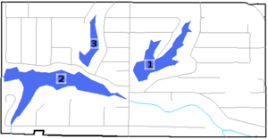
1 – Meshach Lake
2 – Shad Lake
3 – Shadrach Lake
History
The site that would eventually become Royal Lakes was purchased by a Chicago developer in 1956.[5][6] The 320-acre (1.3 km2) tract was to be developed as a resort-style community. Three small lakes – Meshach, Shad, and Shadrach – were constructed for recreational purposes and the remaining land was divided into 2,435 lots, each measuring 25 feet (7.6 m)-by-125 feet.[7] Royal Lakes was marketed as an affordable resort location in a rural setting. The community was heavily promoted in the predominantly African American neighborhoods of St. Louis and East St. Louis.[7] In 1957, the first families moved into Royal Lakes. A communities church was organized in 1961 and the congregation moved into a permanent building seven years later.
Due to Royal Lakes' status as a "resort" area, a lack of zoning regulations meant that there had been no provisions for the developer to provide basic infrastructure. With no road maintenance, water supply, or proper sewage disposal, the overall quality of life for residents of the community deteriorated. By the early 1970s, residents agreed that the only way to improve conditions in the community was through incorporation. An incorporation election was held in October 1972. Of the 98 votes cast, 89 were in favor of incorporation and 9 opposed. Royal Lakes officially became the Village of Royal Lakes.[7][8]
The village's first mayor, Thomas J. Stoddard, and other members of the municipal government took office in April 1973. Incorporating the village did next to nothing to improve the conditions for most residents. Political corruption has plagued the village since it's incorporation and even now has controversy surrounding some of the village officials.
Demographics
| Historical population | |||
|---|---|---|---|
| Census | Pop. | %± | |
| 1980 | 270 | — | |
| 1990 | 272 | 0.7% | |
| 2000 | 190 | −30.1% | |
| 2010 | 197 | 3.7% | |
| Est. 2015 | 190 | [9] | −3.6% |
As of the census[11] of 2000, there were 190 people, 80 households, and 46 families residing in the village. The population density was 408.1 people per square mile (156.1/km²). There were 121 housing units at an average density of 259.9 per square mile (99.4/km²). The racial makeup of the village was 15.79% White, 80.53% African American, 0.53% Native American, 1.05% from other races, and 2.11% from two or more races. Hispanic or Latino of any race were 1.05% of the population.
There were 80 households out of which 26.3% had children under the age of 18 living with them, 42.5% were married couples living together, 15.0% had a female householder with no husband present, and 42.5% were non-families. 40.0% of all households were made up of individuals and 22.5% had someone living alone who was 65 years of age or older. The average household size was 2.38 and the average family size was 3.26.
In the village the population was spread out with 30.5% under the age of 18, 5.3% from 18 to 24, 21.6% from 25 to 44, 21.6% from 45 to 64, and 21.1% who were 65 years of age or older. The median age was 39 years. For every 100 females there were 97.9 males. For every 100 females age 18 and over, there were 76.0 males.
The median income for a household in the village was $17,708, and the median income for a family was $21,042. Males had a median income of $41,667 versus $15,000 for females. The per capita income for the village was $10,049. About 19.1% of families and 27.3% of the population were below the poverty line, including 32.7% of those under the age of eighteen and 27.8% of those sixty five or over.
Education
Public education in the village of Royal Lakes is provided by two school districts. The portion of Royal Lakes lying east of Julian Avenue is served by Bunker Hill Community Unit School District 8. Areas west of Julian Avenue are served by Southwestern Community Unit School District 9.
References
- 1 2 "Village of Royal Lakes". Geographic Names Information System. United States Geological Survey.
- ↑ "Table 4: Annual Estimates of the Resident Population for Incorporated Places in Illinois, Listed Alphabetically: April 1, 2000 to July 1, 2008" (CSV). United States Census Bureau, Population Division. 2009-07-01. Retrieved 2010-03-14.
- ↑ "G001 - Geographic Identifiers - 2010 Census Summary File 1". United States Census Bureau. Retrieved 2015-12-25.
- ↑ "Parks and Recreation". Village of Royal Lakes. Retrieved 2010-03-14.
- ↑ "Royal Lakes Resort". History of Hilyard, Illinois. Village of Royal Lakes. Retrieved 2010-03-17.
- ↑ "Royal Lakes Information". Macoupin County, IL GenWeb. Retrieved 2010-03-17.
- 1 2 3 "The History of the Village of Royal Lakes". Village of Royal Lakes. Retrieved 2010-03-17.
- ↑ "Illinois Counties & Incorporated Municipalities" (PDF). Illinois Secretary of State. May 2006. Retrieved 2010-03-17.
- ↑ "Annual Estimates of the Resident Population for Incorporated Places: April 1, 2010 to July 1, 2015". Retrieved July 2, 2016.
- ↑ "Census of Population and Housing". Census.gov. Retrieved June 4, 2015.
- ↑ "American FactFinder". United States Census Bureau. Retrieved 2008-01-31.
Municipalities and communities of Macoupin County, Illinois, United States | ||
|---|---|---|
| Cities | ||
| Town | ||
| Villages | ||
| Townships | ||
| Unincorporated communities | ||
| Footnotes | ‡This city also has portions in adjacent county or counties | |