Rotherham, New Zealand
| Rotherham | |
|---|---|
| town | |
|
George St in Rotherham | |
 Rotherham | |
| Coordinates: NZ 42°42′S 172°57′E / 42.700°S 172.950°ECoordinates: NZ 42°42′S 172°57′E / 42.700°S 172.950°E | |
| Country | New Zealand |
| Region | Canterbury |
| Territorial authority | Hurunui District |
| Time zone | New Zealand Standard Time (UTC+12) |
| • Summer (DST) | New Zealand Daylight Time (UTC+13) |
| Postcode | 7379 |
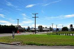
Rotherham is a small village located in the Hurunui District of the Canterbury region in New Zealand's South Island. It is located between Culverden and Waiau on State Highway 70, and is near the south bank of the Waiau River, a popular location for trout and salmon fishing.
On 8 February 1886, a railway was opened to Culverden, but construction then stalled as debate raged about the final route and destination of the line. Some proposals included a line through Rotherham, and in 1914, work finally began on extending the line to Waiau via Rotherham. This extension was opened on 15 December 1919 and the line became known as the Waiau Branch. Rotherham station had a relatively large station building by the standard of rural New Zealand stations, possibly due to plans that suggested terminating the line in Rotherham rather than in Waiau. The station also had stockyards and a goods shed; the stockyards were removed in 1970, and the goods shed was sold and relocated by July 1975. The railway itself closed on 15 January 1978, with the station building left in its original location and acquired for use by a local farmer.
New Zealand State Highway 70 went through Rotherham, but the state highway designation was revoked in 2004.
References
External links
| Wikimedia Commons has media related to Rotherham, New Zealand. |