Rosedale, Queensland
| Rosedale Queensland | |||||||||||||
|---|---|---|---|---|---|---|---|---|---|---|---|---|---|
 Rosedale, 2016 | |||||||||||||
 Rosedale | |||||||||||||
| Coordinates | 24°37′0″S 151°55′0″E / 24.61667°S 151.91667°ECoordinates: 24°37′0″S 151°55′0″E / 24.61667°S 151.91667°E | ||||||||||||
| Population | 448 (2011 census)[1] | ||||||||||||
| Postcode(s) | 4674 | ||||||||||||
| Location | |||||||||||||
| LGA(s) | |||||||||||||
| State electorate(s) | |||||||||||||
| Federal Division(s) | Flynn | ||||||||||||
| |||||||||||||
Rosedale is a town and locality split between the Gladstone Region and the Bundaberg Region in central Queensland, Australia.[2][3][4] At the 2011 census, Rosedale and the surrounding area had a population of 448.[1]
Geography
The town is 423 kilometres (263 mi) north of the state capital Brisbane and 58 kilometres (36 mi) north west of the regional centre of Bundaberg. The town is on the North Coast railway line.
Most of the locality is in the Gladstone Region but a small southern part on the shores of Lake Monduran is in the Bundaberg Region. Despite the town itself being in the Gladstone Region local government area, Rosedale is closer to Bundaberg than Gladstone. There has been some interest in the Rosedale community regarding breaking away from the Gladstone Region.[5]
History

The Rosedale and Tottenham war memorial commemorating the fallen in World War I and World War II is located in James Street, beside the Memorial Hall.[6]
In 2004, a north-bound tilt train derailed injuring 120 passengers.[7]
Education
The town also has a P–12 school catering for students from Rosedale, Lowmead, Agnes Water, 1770, Winfield and Yandaran.[8]
Amentities


Facilities in the town include a pub, a tea house and a general store.[9]
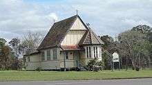
St John's Anglican Church is located in James Street.
The Rosedale cemetery is located north of the town in Ferry Road and is operated by the Gladstone Regional Council.
References
- 1 2 Australian Bureau of Statistics (31 October 2012). "Rosedale (Qld)". 2011 Census QuickStats. Retrieved 5 November 2012.
- ↑ "Rosedale - town (entry 29045)". Queensland Place Names. Queensland Government. Retrieved 22 July 2016.
- ↑ "Rosedale - locality (Gladstone Region) (entry 47307)". Queensland Place Names. Queensland Government. Retrieved 22 July 2016.
- ↑ "Rosedale - locality (Bundaberg Region) (entry 44764)". Queensland Place Names. Queensland Government. Retrieved 22 July 2016.
- ↑ "Residents to be quizzed about breakaway plan". ABC News. Australian Broadcasting Corporation. 10 May 2012. Retrieved 4 November 2012.
- ↑ "Rosedale and Tottenham War Memorial". Queensland War Memorial Register. Queensland Government. Retrieved 22 July 2016.
- ↑ Lion, Patrick; Hammond, Philip (27 November 2008). "Tilt Train crash another blow to Queensland Rail safety record". Courier Mail. Retrieved 5 November 2012.
- ↑ "Rosedale State School: P-12 Campus". The State of Queensland (Department of Education, Training and Employment). Retrieved 5 November 2012.
- ↑ "Rosedale". TotalTravel. Yahoo7. Retrieved 4 November 2012.
External links
![]() Media related to Rosedale, Queensland at Wikimedia Commons
Media related to Rosedale, Queensland at Wikimedia Commons