Roosevelt Island (IND 63rd Street Line)
| Roosevelt Island | |||||||
|---|---|---|---|---|---|---|---|
| New York City Subway rapid transit station | |||||||
 | |||||||
| Station statistics | |||||||
| Address |
Main Street near Road 5 New York, NY 10044 | ||||||
| Borough | Manhattan | ||||||
| Locale | Roosevelt Island | ||||||
| Coordinates | 40°45′33″N 73°57′12″W / 40.759188°N 73.953438°WCoordinates: 40°45′33″N 73°57′12″W / 40.759188°N 73.953438°W | ||||||
| Division | B (IND) | ||||||
| Line | IND 63rd Street Line | ||||||
| Services |
F | ||||||
| Transit connections |
| ||||||
| Structure | Underground | ||||||
| Depth | 100 feet (30 m) | ||||||
| Platforms | 2 side platforms | ||||||
| Tracks | 2 | ||||||
| Other information | |||||||
| Opened | October 29, 1989[1] | ||||||
| Accessible |
| ||||||
| Traffic | |||||||
| Passengers (2015) |
1,966,493[2] | ||||||
| Rank | 252 out of 422 | ||||||
| Station succession | |||||||
|
| |||||||
| Next |
21st Street–Queensbridge: F | ||||||
| Next |
Lexington Avenue–63rd Street: F | ||||||
| |||||||
| |||||||


Roosevelt Island is a station on the IND 63rd Street Line of the New York City Subway. Located in Manhattan on Roosevelt Island in the East River, it is served by the F train at all times.
History
The current 63rd Street Line was the final version of proposals for a northern midtown tunnel from the IND Queens Boulevard Line to the Second and Sixth Avenue lines, which date back to the IND Second System of the 1920s and 1930s.[3][4][5][6] The current plans were drawn up in the 1960s under the MTA's Program For Action.[7] On February 16, 1965, the New York City Transit Authority announced plans to construct a subway station on the island along the 63rd Street Line, as part of the island's proposed transit-oriented development. The construction of a station was viewed to be vital for the development of the island, which was then known as Welfare Island. At that point, it was decided to have a shell built for the station, to allow for the station to open after the opening of the rest of the line, with a projected savings of $4 million compared to if the station was built as a infill station after the rest of the line opened. The projected cost of the station was $3,300,000.[8]
This station opened on October 29, 1989[9] along with the entire IND 63rd Street Line.[1][10] The Q train served the station on weekdays and the B train stopped there on the weekends; both services used the Sixth Avenue Line.[1] For the first couple of months after the station opened, the JFK Express to Kennedy Airport also served the station until it was discontinued in 1990.[11] The tunnel had gained notoriety as the "tunnel to nowhere" both during its planning and after its opening.[1][6] Roosevelt Island was the second-to-last stop before 21st Street–Queensbridge, the line's northern terminus; the 21st Street station was not connected to any other subway station or line in Queens[1][6] until the connection to the Queens Boulevard Line was completed and opened in 2001. Thereafter, the station began being served by the F train, which serves Roosevelt Island to this day.[12][13][14][15][16]
At an April 14, 2008, news conference, Governor David Paterson announced that the MTA will power a substantial portion of the station using tidal energy generated by turbines located in the East River which are part of the Roosevelt Island Tidal Energy Project.[17] This is part of a larger MTA initiative to use sustainable energy resources within the subway system.[18]
Station layout
| G | Street Level | Exit/Entrance |
| B1 | Upper Mezzanine | Fare control, station agent, MetroCard vending machines |
| B2 | Lower Mezzanine | Transfer between platforms |
| B3 Platform level |
Side platform, doors will open on the right | |
| Southbound | ← | |
| Northbound | → | |
| Side platform, doors will open on the right | ||
| B4 | Track 1 | ← LIRR East Side Access (under construction) |
| Track 2 | → LIRR East Side Access (under construction) → | |
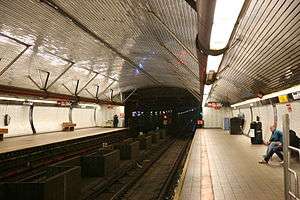
The station has two tracks and two side platforms. It is the fourth-deepest station in the New York City Subway at about 100 feet (30 m) below street level (approximately 10 stories deep) behind 34th Street – Hudson Yards, 190th Street, and 191st Street stations, also in Manhattan.[19] Due to its depth, the station contains several features not common in the rest of the system. Similar to stations of the Paris Metro and Washington Metro, the Roosevelt Island station was built with a high vaulted ceiling and a mezzanine directly visible above the tracks. These features can also be found on some of the system's other deep stations, including Grand Central, 168th Street, and 181st Street stations, along with future stations along the Second Avenue Subway.
The station is fully ADA-accessible, with elevators to street level. Fare control is in a glass-enclosed headhouse building off of Main Street.[20] West of this station, there is a diamond crossover[21] and two bellmouths that curve southward toward an unbuilt portion of the Second Avenue Subway. There is an emergency exit from the future LIRR's lower level at the middle of each platform.
The headhouse has a feature that is unusual to the subway system: it uses recordings of birds to try to scare away city pigeons, and these bird recordings play every few minutes or so. This is because of issues with pigeons entering the headhouse and leaving feathers and droppings both inside and around the building. Previous efforts, like spiked ledges, had been ineffective in curbing the pigeon population of the area immediately next to the station.[22]
Ridership
In 2008, the station saw about 5,900 daily riders, compared to 3,000 for the Roosevelt Island Tramway.[23] In 2015, an average of 6,197 daily riders used the station on an average weekday.[24] This amounted to 1,966,493 total riders entering the station in 2015.[2]
Nearby points of interest
- Firefighters Field[25]
- Goldwater Memorial Hospital[20]
- Good Shepherd Church[20]
- Roosevelt Island Tramway – to 2nd Avenue and 60th Street, Manhattan[20]
Gallery
-

Platforms and tracks
-

Station Entrance
-

The lengthy escalator between the mezzanine and the headhouse
References
- 1 2 3 4 5 Lorch, Donatella (October 29, 1989). "The 'Subway to Nowhere' Now Goes Somewhere". The New York Times. Retrieved 2009-09-26.
- 1 2 "Facts and Figures: Annual Subway Ridership". New York City Metropolitan Transportation Authority. Retrieved 2016-04-19.
- ↑ Joseph B. Raskin (1 November 2013). The Routes Not Taken: A Trip Through New York City's Unbuilt Subway System. Fordham University Press. ISBN 978-0-8232-5369-2. Retrieved 12 August 2015.
- ↑ Roger P. Roess; Gene Sansone (23 August 2012). The Wheels That Drove New York: A History of the New York City Transit System. Springer Science & Business Media. pp. 416–417. ISBN 978-3-642-30484-2.
- ↑ Project for Expanded Rapid Transit Facilities, New York City Transit System, dated July 5, 1939
- 1 2 3 Knowles, Clayton (December 16, 1964). "Proposed Subway Tube Assailed As 'Nowhere‐to‐Nowhere' Link". The New York Times. Retrieved 27 September 2015.
- ↑ "Full text of "Metropolitan transportation, a program for action. Report to Nelson A. Rockefeller, Governor of New York."". Internet Archive. November 7, 1967. Retrieved October 1, 2015.
- ↑ "WELFARE ISLAND TO BE ON SUBWAY; Station to Be Built in New 63d St. Tunnel to Queens". Retrieved 2016-10-10.
- ↑ 63 St Subway Extension Opened 25 Years Ago this Week
- ↑ Kershaw, Sarah (December 17, 2001). "V Train Begins Service Today, Giving Queens Commuters Another Option". The New York Times. Retrieved 2011-10-16.
- ↑ Grynbaum, Michael M. (November 25, 2009). "If You Took the Train to the Plane, Sing the Jingle". Retrieved 2016-07-03.
- ↑ "Review of F Line Operations, Ridership, and Infrastructure" (PDF). nysenate.gov. MTA New York City Transit Authority. October 7, 2009. Archived from the original (PDF) on 2010-05-31. Retrieved 28 July 2015.
- ↑ "Review of the G Line" (PDF). mta.info. Metropolitan Transportation Authority. July 10, 2013. Retrieved 2 August 2015.
- ↑ O'Neill, Natalie (April 13, 2012). "History shows it's not the G train 'extension' — it's the G train renewal". The Brooklyn Paper. Retrieved 2 August 2015.
- ↑ "E,F Detour in 2001, F trains via 63 St, E no trains running, take R instead". The Subway Nut. Retrieved October 20, 2011.
- ↑ Kennedy, Randy (May 25, 2001). "Panel Approves New V Train but Shortens G Line to Make Room". The New York Times. Retrieved March 20, 2010.
- ↑ "Roosevelt Island Tidal Energy Project". Devine Tarbell & Associates, Inc. Retrieved 2011-10-16.
- ↑ Ehrlich, David (April 15, 2008). "New York transit going green". Clean Tech Group, LLC. Archived from the original on April 20, 2008.
- ↑ The Deepest and Highest Subway Stations in NYC: 191st St, 190th Street, Smith & 9th
- 1 2 3 4 "MTA Neighborhood Maps: Long Island City" (PDF). Metropolitan Transportation Authority. 2015. Retrieved 27 September 2015.
- ↑ Marrero, Robert (2015-09-13). "469 Stations, 846 Miles" (PDF). B24 Blog, via Dropbox. Retrieved 2015-10-09.
- ↑ Haughney, Christine (2012-03-18). "M.T.A. Uses Bird Recordings to Scare Pigeons From Roosevelt Island Station". The New York Times. ISSN 0362-4331. Retrieved 2016-07-26.
- ↑ Hernandez, Javier C. (2008-06-14). "What Is Life Without a Tram? Residents Are Getting a Taste". The New York Times. ISSN 0362-4331. Retrieved 2016-07-26.
- ↑ "Facts and Figures: Average Weekday Subway Ridership". web.mta.info. Metropolitan Transportation Authority. Retrieved 2016-07-26.
- ↑ "Louis Pasteur Park Highlights - Firefighter Field : NYC Parks". www.nycgovparks.org. Retrieved 2016-07-28.
External links
| Wikimedia Commons has media related to Roosevelt Island (IND 63rd Street Line). |
- nycsubway.org – IND 6th Avenue: Roosevelt Island
- F Train at Station Reporter
- Station house and entrance from Google Maps Street View
- Platforms from Google Maps Street View
- Mezzanine from Google Maps Street View
- Lobby from Google Maps Street View