Rollinsville, Colorado
| Rollinsville, Colorado | |
|---|---|
| Census-designated place | |
|
Businesses along State Highway 119 in Rollinsville | |
 Rollinsville  Rollinsville | |
| Coordinates: 39°54′59″N 105°30′03″W / 39.91639°N 105.50083°WCoordinates: 39°54′59″N 105°30′03″W / 39.91639°N 105.50083°W | |
| Country |
|
| State |
|
| County | Gilpin County[1] |
| Area | |
| • Total | 1.41 sq mi (3.66 km2) |
| • Land | 1.41 sq mi (3.66 km2) |
| • Water | 0.0 sq mi (0.0 km2) |
| Elevation[1] | 8,474 ft (2,583 m) |
| Population (2010) | |
| • Total | 181 |
| • Density | 128/sq mi (49.5/km2) |
| Time zone | MST (UTC-7) |
| • Summer (DST) | MDT (UTC-6) |
| ZIP code[2] | 80474 |
| GNIS feature ID | 0202787 |
| FIPS code | 08-65685 |
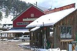
Rollinsville is a census-designated place and a U.S. Post Office located in Gilpin County, Colorado, United States. It is located in the mountains southwest of the city of Boulder, on the flank of a hill above South Boulder Creek along State Highway 119 between Nederland and Black Hawk. It consists of a small cluster of residences and several businesses at the terminus of the road leading westward up to Rollins Pass at the summit of the Front Range. The population as of the 2010 Census was 181.[3] The Rollinsville post office has the ZIP Code 80474.[2]
A post office called Rollinsville has been in operation since 1871.[4] The community was named for John Q. A. Rollins, a prominent mining executive in Gilpin County in the 1860s and 1870s.[5]
Geography
Rollinsville is located in northern Gilpin County at 39°54′59″N 105°30′03″W / 39.91639°N 105.50083°W (39.916320,-105.500851), along Colorado State Highway 119, the Peak to Peak Highway. It is 5 miles (8 km) south of Nederland and 14 miles (23 km) north of Black Hawk.
The South Fork of Boulder Creek flows just south of the town. The creek follows the railroad tracks into a small canyon and emerges near the Boulder/Gilpin county border before flowing through Pinecliffe, Colorado.
See also
- Outline of Colorado
- State of Colorado
- Moffat Tunnel
- Peak to Peak Highway
- United States Forest Service
References
- 1 2 "US Board on Geographic Names". United States Geological Survey. 2007-10-25. Retrieved 2008-01-31.
- 1 2 "ZIP Code Lookup" (JavaScript/HTML). United States Postal Service. January 2, 2007. Retrieved January 2, 2007.
- ↑ "Geographic Identifiers: 2010 Demographic Profile Data (G001): Rollinsville CDP, Colorado". American Factfinder. U.S. Census Bureau. Retrieved November 17, 2016.
- ↑ "Post offices". Jim Forte Postal History. Retrieved 9 July 2016.
- ↑ Dawson, John Frank. Place names in Colorado: Why 700 communities were so named, 150 of Spanish or Indian origin. Denver, CO: The J. Frank Dawson Publishing Co. p. 43.
Municipalities and communities of Gilpin County, Colorado, United States | ||
|---|---|---|
| Cities | 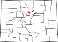 | |
| CDPs | ||
| Unincorporated communities | ||
| Footnotes | ‡This populated place also has portions in an adjacent county or counties | |