Rodovia dos Imigrantes
| |
|---|---|
|
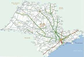
Map of the itinerary of Imigrantes Highway (in red) | |
|
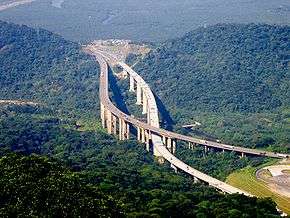
A view of the north and south carriageways of Rodovia dos Imigrantes, one crossing over the other at (23°53′55.27″S 46°28′14.97″W / 23.8986861°S 46.4708250°W) | |
| Route information | |
| Maintained by Ecovias | |
| Length: | 72 km (45 mi) |
| Existed: |
1974 (north lane) 2002 (south lane) – present |
| Major junctions | |
| North end: | Av. Prof. Abraão de Morais in São Paulo, SP |
|
| |
| South end: | Avenida Ayrton Senna in Praia Grande, SP |
| Highway system | |
|
Highways in Brazil | |
Rodovia dos Imigrantes (official designation SP‑160) is a highway in the state of São Paulo, Brazil. The highway connects the city of São Paulo to the Atlantic coast and with the seaside cities of São Vicente and Praia Grande. It follows the route of Rodovia Anchieta and is also one of Brazil's busiest highways, especially on weekends.
Rodovia dos Imigrantes has 44 viaducts, 7 bridges, and 11 tunnels, along its 58.5 km stretch. The highway has recently been expanded, in one of the most audacious feats of Brazilian highway engineering, with extremely long tunnels and high strutting six-lane bridges constructed over the tropical rain forest, which covers the steep faces of the Serra do Mar, the cliff range that separates the São Paulo plateau from the seaside lowlands. During sunny weekends, more than 1 million automobiles commonly cross its near 60 km run, separating the city of São Paulo from the sea.
Rodovia dos Imigrantes was inaugurated in 1974, due to traffic saturation on Rodovia Anchieta. Although longer than Anchieta, Rodovia dos Imigrantes is nowadays busier due to its building standards, which permit higher speed limits, and its more direct path to the cities of Santos and Guarujá, the northern coast (with Bertioga), as well as the southern coast (with cities Praia Grande, Mongaguá, and Itanhaém.
Meaning "immigrants' highway" in Portuguese, Rodovia dos Imigrantes was so named as a way to remember the contribution of immigrants to the cultural, economic, and social development of Brazil.
It is managed by a state concession to the private company, Ecovias, which also maintains Rodovia Anchieta; it is, therefore, a toll road.
The two carriageways of Rodovia dos Imigrantes are both fully reversible and traffic is managed to flow either bidirectionally (uphill on one carriageway and downhill on the other) or unidirectionally (uphill or downhill on both carriageways), depending on demand. In the unidirectional mode, the opposing traffic is diverted to Rodovia Anchieta.
Directions
The path of the Immigrant Road crosses the following municipalities, all in the state of São Paulo. |São Paulo | Diadema | São Bernardo do Campo | Cubatão | São Vicente | Praia Grande
See also
External links
| Rodovias | |
|---|---|
| Expressways |
|
| Surface streets |
|