Ottawa/Rockcliffe Airport
| Ottawa/Rockcliffe Airport | |||||||||||
|---|---|---|---|---|---|---|---|---|---|---|---|
 | |||||||||||
| IATA: YRO – ICAO: CYRO | |||||||||||
| Summary | |||||||||||
| Airport type | Public | ||||||||||
| Operator | Rockcliffe Flying Club | ||||||||||
| Location | Ottawa, Ontario | ||||||||||
| Time zone | EST (UTC−05:00) | ||||||||||
| • Summer (DST) | EDT (UTC−04:00) | ||||||||||
| Elevation AMSL | 188 ft / 57 m | ||||||||||
| Coordinates | 45°27′37″N 075°38′46″W / 45.46028°N 75.64611°WCoordinates: 45°27′37″N 075°38′46″W / 45.46028°N 75.64611°W | ||||||||||
| Website | Rockcliffe Flying Club | ||||||||||
| Map | |||||||||||
 CYRO Location in Ontario | |||||||||||
| Runways | |||||||||||
| |||||||||||
|
Source: Canada Flight Supplement[1] | |||||||||||
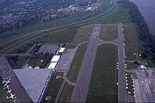
Ottawa/Rockcliffe Airport or Rockcliffe Airport, (IATA: YRO, ICAO: CYRO), a former military base, is a non-towered airport located on the south shore of the Ottawa River, 4 nautical miles (7.4 km; 4.6 mi) northeast of Downtown Ottawa, Ontario, Canada. The airport is the home of the Canada Aviation Museum, which owns the field, and is used and maintained by the Rockcliffe Flying Club.
History
The airport land was originally a military rifle range. In 1918, the Royal Air Force began using the field behind the range for experimental mail flights, and the airport opened officially in 1920 as the Ottawa Air Station, one of the six original airfields opened across Canada by the new Air Board. Since it is on the shore of the Ottawa river and the runways were connected to the riverfront by a road, it was one of very few airports capable of handling and transferring floatplanes on both land and water. On March 12, 1930, Canadian World War I flying ace William George Barker crashed into the Ottawa River and died during an aerial demonstration over the field. In July 1931, Charles Lindbergh and Anne Morrow Lindbergh visited the airport during their northern surveying tour. During World War II. Rockcliffe participated in the British Commonwealth Air Training Program and many other kinds of testing, training, and transport operations, including flying overseas mail to troops in Europe.
The military importance of the airport declined after World War II, since the runways were too short for typical jet operations. The armed forces shifted most operations to RCAF Station Uplands (now Ottawa Macdonald-Cartier International Airport) in 1957, and ceased flying operations at Rockcliffe in 1964, retaining the station only as an administrative base, while the Rockcliffe Flying Club began using the field for civilian flying.
During the 1970s the airport was also used for scheduled short takeoff and landing (STOL) commercial flights to the short-lived Victoria STOLport near downtown Montreal.[2] The objective was to demonstrate Twin Otter STOL aircraft in downtown areas and avoid longer drives to the Ottawa and Montreal airports. For a variety of reasons STOL operations in downtown settings have not proven successful.
The military left the airport completely in 1994, but their aircraft collection remained to form the nucleus of the Canada Aviation Museum. Only one of the former triangle of runways remains active; runways 04/22 and 10/28 were closed along with most taxiways now servicing the aviation museum.
Tenants
Current tenants of the airport:
- Canadian Aviation Museum - two buildings
- Rockcliffe Flying Club
- Rockcliffe Yacht Club
Former tenants:
- Canadian Forces (RCAF, Canadian Army) - 1920-1964
- Dominion of Canada Rifle Association
- Airtransit - a wholly owned subsidiary of Air Canada used Rockcliffe to demonstrate STOL passenger operations to Victoria STOLport in Montreal from 1974 to 1976[3]
Transportation to Airport
By car the airport can be reached by Rockcliffe Parkway.
By transit OC Transpo Route 129 provides direct access to airport or Route 7 with a short walk to the airport.[4]
Incidents
- March 28, 1950 – USAF Douglas C-47B-50DK had an engine fire and crashed shortly after takeoff, resulting in 5 fatalities (including American Ambassador Laurence Steinhardt) and one survivor.
- July 22, 1953 – RCAF Canadair C-54GM Argonaut catches fire during loading; aircraft was destroyed with no fatalities
See also
References
- ↑ Canada Flight Supplement. Effective 0901Z 15 September 2016 to 0901Z 10 November 2016
- ↑ "The Airtransit operation". FLIGHT International. www.flightglobal.com. 28 November 1974. Retrieved 2009-01-05.
- ↑ http://www.flightglobal.com/pdfarchive/view/1974/1974%20-%201919.html
- ↑ http://casmuseum.techno-science.ca/en/visit/directions.php
External links
| Wikimedia Commons has media related to Ottawa/Rockcliffe Airport. |
- Rockcliffe Flying Club
- "Photo essay of the airport's history" (PDF). (2.49 MiB)
| By name | |
|---|---|
| By location indicator | |
| By province/territory | |
| By region | |
| National Airports System | |
| Related | |
| |