Robert (Bob) Curtis Memorial Airport
| Robert (Bob) Curtis Memorial Airport | |||||||||||
|---|---|---|---|---|---|---|---|---|---|---|---|
 | |||||||||||
| IATA: ORV – ICAO: PFNO – FAA LID: D76 | |||||||||||
| Summary | |||||||||||
| Airport type | Public | ||||||||||
| Owner | State of Alaska DOT&PF - Northern Region | ||||||||||
| Serves | Noorvik, Alaska | ||||||||||
| Elevation AMSL | 55 ft / 17 m | ||||||||||
| Coordinates | 66°49′03″N 161°01′20″W / 66.81750°N 161.02222°W | ||||||||||
| Runways | |||||||||||
| |||||||||||
| Statistics | |||||||||||
| |||||||||||
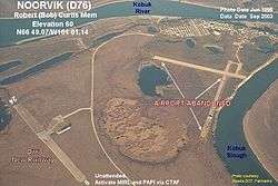
Robert (Bob) Curtis Memorial Airport (IATA: ORV[3], ICAO: PFNO[4], FAA LID: D76) is a state-owned public-use airport located one nautical mile (1.8 km) north of the central business district of Noorvik, a village in the Northwest Arctic Borough of the U.S. state of Alaska.[1]
As per Federal Aviation Administration records, this airport had 6,523 passenger boardings (enplanements) in calendar year 2007, a decrease of 5% from the 6,884 enplanements in 2006.[2]
Facilities
Robert (Bob) Curtis Memorial Airport covers an area of 311 acres (126 ha) at an elevation of 55 feet (17 m) above mean sea level. It has one runway (6/24) with a gravel surface measuring 4,000 by 100 feet (1,219 by 30 m).[1]
Airlines and non-stop destinations
| Airlines | Destinations |
|---|---|
| Bering Air | Kiana, Kotzebue |
| Frontier Flying Service | Kiana, Selawik[5] |
| Hageland Aviation Services | Kiana[6] |
References
- 1 2 3 FAA Airport Master Record for D76 (Form 5010 PDF), effective 2008-09-25
- 1 2 Preliminary CY 2007 Passenger Boarding and All-Cargo Data. Federal Aviation Administration. 2008-07-17.
- ↑ ORV: Noorvik-Curtis Memorial Airport, Alaska. Aviation Safety Network. Retrieved 2008-09-21.
- ↑ PFNO: Robert (Bob) Curtis Memorial Airport, Noorvik, Alaska. AirNav.com. Retrieved 2008-09-21.
- ↑ Frontier Flying Service: 2007 Timetable (PDF). Retrieved 31-Aug-2007.
- ↑ Bering Air: Kotzebue Flight Schedule (PDF). Retrieved 31-Aug-2007.
External links
- FAA Alaska airport diagram (GIF)
- Resources for this airport:
- FAA airport information for D76
- AirNav airport information for D76
- ASN accident history for ORV
- FlightAware airport information and live flight tracker
- SkyVector aeronautical chart for D76
This article is issued from Wikipedia - version of the 11/28/2015. The text is available under the Creative Commons Attribution/Share Alike but additional terms may apply for the media files.