River Torrent
River Torrent is a river in County Tyrone, Northern Ireland which enters the River Blackwater approximately 4 km (2.5 mi) from Maghery ferry.[1] It was a great source of industrial waterpower.[2] The river flows through the small village of Newmills in East Tyrone, situated three miles north of Dungannon.[3] Donaghmore village is situated adjacent to the River Torrent, formerly known as the Torrent Flow.[4]
Geology
The Torrent is a long meandering river, which drains the hills to the north-west of Dungannon. The underlying geology is varied and includes basal clastic, carboniferous limestone, coal and Old Red Sandstone. In the upper reaches, the river channel is shallow and narrow with pebble/cobble substrate and sandy banks. Downstream the banks are vegetated with tall grasses and native tree species. There are also fishing weirs. In its lower reaches, the Torrent widens and runs parallel to the Coalisland Canal.[5]
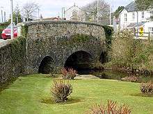
Dukart's Canal
Dukart's Canal was built to provide transport for coal from the Drumglass Colleries to the Coalisland Canal, in County Tyrone. The most prominent canal structure still extant is the ashlar stone aqueduct at Newmills, built around 1778, where the canal was carried over the River Torrent.[6]
See also
References
- ↑ "Navigating the River Blackwater". Culture Northern Ireland. Retrieved 28 November 2007.
- ↑ "Coalisland - Torrent River". Culture Northern Ireland. Archived from the original on 11 January 2008. Retrieved 28 November 2007.
- ↑ "Newmills Potted History". Culture Northern Ireland. Archived from the original on 11 January 2008. Retrieved 28 November 2007.
- ↑ "Donaghmore Area Profile". Donaghmore Living History. Retrieved 1 March 2009.
- ↑ "Torrent River". Planning Service - Dungannon and South Tyrone Area Plan 2010. Retrieved 1 March 2009.
- ↑ Skempton, A.W. & Chrimes, Mike (2002). A Biographical Dictionary of Civil Engineers in Great Britain and Ireland: 1500 to 1830. Thomas Telford. p. 191. ISBN 0-7277-2939-X.
Coordinates: 54°30′15″N 6°38′16″W / 54.50429°N 6.63789°W