River Blackwater (Northern Ireland)
| River Blackwater | |
|---|---|
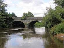 The bridge over the River Blackwater which connects Charlemont, County Armagh, to The Moy, County Tyrone. | |
| Native name | Cluain-Dabhail / An Abhainn Mhór |
| Country | Northern Ireland |
| Basin | |
| Main source |
north of Augher, County Tyrone 59 metres (194 ft) |
| River mouth | Atlantic Ocean at Portstewart |
| Basin size | 1,507 square kilometres (582 sq mi) |
| Physical characteristics | |
| Length | 91.3 kilometres (56.7 mi) |
| Discharge |
|
| Features | |
| Tributaries |
|
The River Blackwater or Ulster Blackwater is a river in County Armagh and County Tyrone, Northern Ireland. It also forms part of the border between the United Kingdom and the Republic of Ireland, flowing between counties Tyrone and Monaghan, intersecting into Monaghan briefly. Its source is to the north of Fivemiletown, County Tyrone. The river divides County Armagh from County Tyrone and also divides County Tyrone from County Monaghan.
Route
The river enters Lough Neagh west of Derrywarragh Island and is navigable from Maghery to Blackwatertown. The small Maghery Canal enters the Blackwater south of Derrywarragh Island. Nearby a small jetty area with a slipway, is the site of the former Maghery ferry. Approximately 4 km from Maghery ferry is the entrance to the river 200m beyond Bond’s Bridge. Just past it, on the east bank, is a large country house estate called the Argory, donated to the National Trust by the McKeogh Bond family. The Callan River joins the Blackwater 1.6 km upstream. Further on, at a bend on the east bank, is the entrance to the first lock of the Ulster Canal. Just upstream, Charlemont Bridge joins the town of Charlemont on the east bank and Moy on the west.[1]
The Blackwater's length is 91.3 km (56.75ml).[2] If the Blackwater's flow is measured through its path through the 30 km (19ml) Lough Neagh and onwards to the sea via the 64.4 km (40ml) Lower Bann, the total length is 186.3 km (115.75ml). This makes the Blackwater–Neagh–Bann the longest natural stream flow in Ulster and is longer than the Munster Blackwater.
Ancient name
Anciently the River Blackwater was known in Irish as Cluain-Dabhail meaning "meadow of Dabhal". This was anglicised as Clanaul, the former name of the parish of Eglish, as well as Glenaul, which was used as the name of the former local District Electoral Division of Armagh Union.[3]
Angling
In the lower part of the reach mainly upstream of Blackwatertown Bridge, coarse fish abound, but there is a short stretch of good game fishing water downstream of the island where there are a number of known salmon lies. Game fish stocks are now recovering following a drainage scheme in the late 1980s and restoration of the system.[4]

History
| River Blackwater | |||||||||||||||||||||||||||||||||||||||||||||||||||||||||||||||||||||||||||||||||||||||||||||||||||||||||||||||||||||||||||||||||||||||||||||||||||||||||||||||||||||||||||||||||||||||||||||||||||||||||||||||||||||||||||||||||||||||||
|---|---|---|---|---|---|---|---|---|---|---|---|---|---|---|---|---|---|---|---|---|---|---|---|---|---|---|---|---|---|---|---|---|---|---|---|---|---|---|---|---|---|---|---|---|---|---|---|---|---|---|---|---|---|---|---|---|---|---|---|---|---|---|---|---|---|---|---|---|---|---|---|---|---|---|---|---|---|---|---|---|---|---|---|---|---|---|---|---|---|---|---|---|---|---|---|---|---|---|---|---|---|---|---|---|---|---|---|---|---|---|---|---|---|---|---|---|---|---|---|---|---|---|---|---|---|---|---|---|---|---|---|---|---|---|---|---|---|---|---|---|---|---|---|---|---|---|---|---|---|---|---|---|---|---|---|---|---|---|---|---|---|---|---|---|---|---|---|---|---|---|---|---|---|---|---|---|---|---|---|---|---|---|---|---|---|---|---|---|---|---|---|---|---|---|---|---|---|---|---|---|---|---|---|---|---|---|---|---|---|---|---|---|---|---|---|---|---|---|---|---|---|---|---|---|---|---|---|---|---|---|---|---|---|
Legend | |||||||||||||||||||||||||||||||||||||||||||||||||||||||||||||||||||||||||||||||||||||||||||||||||||||||||||||||||||||||||||||||||||||||||||||||||||||||||||||||||||||||||||||||||||||||||||||||||||||||||||||||||||||||||||||||||||||||||
| |||||||||||||||||||||||||||||||||||||||||||||||||||||||||||||||||||||||||||||||||||||||||||||||||||||||||||||||||||||||||||||||||||||||||||||||||||||||||||||||||||||||||||||||||||||||||||||||||||||||||||||||||||||||||||||||||||||||||
The inland waterways network of Ireland had developed in the latter part of the eighteenth century, and in 1814, the Directors General of Inland Navigation were keen to join the various parts together. This required a link between Lough Neagh and Lough Erne, and another between Lough Erne and the River Shannon. Accordingly, they asked John Killaly, their engineer, to look at the first of these routes, "in general terms". Although the Directors did not proceed immediately, due to lack of funds, the scheme was revived in 1822 and the canal was eventually completed in 1841. Below the first lock at Charlemont, the canal joined the river, and used the river channel to reach Lough Neagh. The venture was not a success, as significant volumes of traffic failed to develop, and the canal was taken over by the Board of Works in 1851.[5]
Meanwhile, The Office of Public Works (The O.P.W., often known as 'the Board of Works') had obtained powers in 1842 to carry out various projects around the Lough Neagh basin, with the intent of improving drainage, navigation and mill-power. Following a survey by their engineer John McMahon, a scheme was developed to make the Lower Bann navigable from Lough Neagh to the sea. This involved removing a great shoal of rock at Portna which had the effect of lowering the level of Lough Neagh by around 6 feet (1.8 m). This had a significant effect on the Blackwater, and major work was required on the river to keep it navigable. The Maghery Cut, which gave access to Lough Neagh to the south of Derrywarragh Island, had to be made deeper and wider, and the channel of the river was dredged, to maintain a navigable depth. The final lock on the Coalisland Canal and the Ulster Canal had to be reconstructed with a lower cill and deeper gates, to accommodate the lower level of the river, as did the final lock on the Newry Canal where it joined the Upper Bann.[6]
The total cost of the project, split between navigation and drainage work, was estimated at £183,775.[7] The cost of work on the Blackwater exceeded that on any of the other tributaries to Lough Neagh. While the first 5 miles (8 km) of the river above the lough was large and wide, considerable work was needed between there and Blackwatertown to eradicate sharp bends and shoals. New sections of river channel were cut, and were made between 80 and 90 feet (24 and 27 m) wide, with their depth sufficient to provide 6 feet (1.8 m) of water when Lough Neagh was at it lowest designed level during the summer months. Excavated material was used to backfill the old river channels, so that loss of land was reduced. To protect the surrounding low-lying land from flooding by the river, the channel was embanked. The embankments were designed with self-acting sluices, to allow tributaries to pass through them when water levels were suitable. After some of the embankments had been finished, local landowners petitioned against their completion, as they felt that the lower level of Lough Neagh and the works already carried out gave them sufficient protection, and it was inadvisable to completely protect the land. The defense work was thus deferred.[8]
The original plans were to embank the Tall River and the Callan River which joined together to the south of Clonmain, and flowed into the Blackwater below Charlemont bridge. This aspect of the project was reworked, and a new straight cut was made from a point on the Tall River to the north of Clonmain, crossing Sir William Verner's bog, and rejoining the Blackwater just above Verners Bridge, some 5 miles (8 km) below the original confluence. This had the advantage that under flood conditions, the water level in the Blackwater was from 4 to 5 feet (1.2 to 1.5 m) lower than that further upstream. The channel below Verners Bridge was also considerably wider, and so could better cope with the volumes of water discharged by the two tributaries.[9]
The project took eleven years to complete, by which time costs had overrun by £50,000. The government were approached to make up the shortfall, and did so. When the scheme began, there was to be a single controlling authority to maintain the works, with the more profitable Lower Bann helping to fund the less profitable Blackwater and Upper Bann. However, by the time it was completed, three separate and independent trusts were set up. The Upper Bann and the Blackwater were managed by the Upper Bann Navigation Trust. The counties to the south of Lough Neagh were expected to fund their part of the drainage and navigation works, and to contribute £800 per year towards the running of the Trust, with no income to meet this figure.[7] The Lower Bann Navigation Trust and the Lough Neagh Drainage Trust were wound up in 1929, with their responsibilities passing to the Ministry of Finance, but despite vigorous campaigning by the counties supporting the Upper Bann Navigation Trust, the government refused to disband it, and it continued to be funded until 1954, when the Ministry of Commerce took over the waterways and effectively closed them.[10]
See also
Bibliography
- CPW-I, Commissioners of Public Works (Ireland) (1853). "Twentieth report 1852-1853". HMSO (Enhanced parliamentary papers on Ireland).
- Cumberlidge, Jane (2002). The Inland Waterways of Ireland. Imray Laurie Norie and Wilson. ISBN 978-0-85288-424-9.
- Delany, Ruth (2004). Ireland's Inland Waterways. Appletree Press. ISBN 978-0-86281-824-1.
References
| Wikimedia Commons has media related to River Blackwater, Ulster. |
- ↑ "Navigating the River Blackwater". Culture Northern Ireland. Archived from the original on 10 February 2008. Retrieved 28 November 2007.
- ↑ Ordnance Survey of Ireland: Rivers and their Catchment Basins 1958 (Table of Reference)
- ↑ Archive.org, Ulster Journal of Archaeology
- ↑ "River Blackwater". Discover Northern Ireland. Retrieved 28 February 2009.
- ↑ Delany 2004, pp. 150-153.
- ↑ Delany 2004, pp. 166-167.
- 1 2 Delany 2004, p. 167.
- ↑ CPW-I 1853, p. 216.
- ↑ CPW-I 1853, pp. 216-217.
- ↑ Delany 2004, p. 169.
Coordinates: 54°30′41″N 6°34′42″W / 54.51132°N 6.57832°W