Ewenny River
| Ewenny River (Afon Ewenni) | |
| River | |
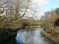 The river at Ewenny, the village to which it gave its name. | |
| Countries | United Kingdom, Wales |
|---|---|
| Region | South Wales |
| County | Vale of Glamorgan |
| Tributaries | |
| - left | Afon Alun, Afon Ewenni Fach, Nant Canna, Nant Crymlyn |
| Cities | Pencoed, Ewenny, Ogmore |
| Source | |
| - location | North of Pencoed, Bridgend County Borough, Bridgend, Wales |
| Length | 11.0 km (7 mi) |
The Ewenny River (Welsh: Afon Ewenni) is a small river in south Wales with a length of ten miles or sixteen kilometres. For most of its length it forms the border between the counties of the Vale of Glamorgan and Bridgend. It is a major tributary of the River Ogmore, which it joins over a mile upstream from the sea.
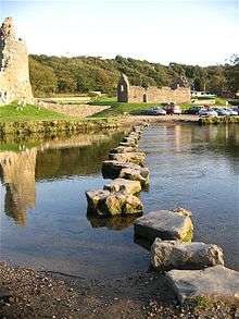
Ogmore Castle is sited on the river.[1]
Course
The river rises to the north east of Bridgend town, in South Wales, where two minor rivers known as Ewenny Fach and Ewenny Fawr join. Ewenny Fach is considered a tributary of the Ewenny Fawr, which in turn is formed when three streams, Nant Canna, Nant Ciwc and Nant Crymlyn join. This branch of the river flows southeast, past the village of Pencoed and under the M4 Motorway until it is joined by the Ewenny Fach south of Junction 35 of the road . From here, the river turns southward and flows through the Ewenni Moor, past the village of Waterton. Waterton is the site of a large industrial estate, and a few miles of meandering river were straightened and diverted to prevent flooding. The river flows through the villages of Ewenny and Ogmore, before entering the River Ogmore estuary just below Ogmore Castle. One of its main tributaries is the Afon Alun, which flows west for a few miles, and converges with the Ewenny north of Ogmore.
Fishing
The river has very good grayling, and also sewin.[2]
Mouth
The river joins the Ogmore near Ogmore Castle, which is south of the river. At the confluence, a series of stepping stones cross the river. However, these only cross the Ewenny river, and not the Ogmore.
References
- ↑ "Ogmore Castle and Stepping Stones". visitwales.com. Welsh Government. Retrieved 19 February 2016.
- ↑ "River Ewenny". Sewin Fly. Retrieved 30 May 2011.
External links
Coordinates: 51°28′55″N 3°36′27″W / 51.48197°N 3.60737°W
| Communities |  | |
|---|---|---|
| Towns and villages |
| |
| Castles | ||
| Rivers | ||
| Topics | ||