Rhydargaeau
Coordinates: 51°54′48″N 4°16′19″W / 51.9133°N 4.27197°W
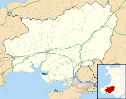
Rhydargaeau is a village in Carmarthenshire, Wales. It lies along the A485 road which connects it to Pontarsais in the north and Peniel and Carmarthen, 3.8 miles (6.1 km) to the south. The village is located in the community of Llanllawddog.[1] The village pub is the Bluebell and Rhydargaeau also contains a Baptist church and Upper Llawddog Pump House.[2][3]
Notable people
- Esther Lewis (1887-1958), missionary[4]
References
- ↑ Davies, John; Jenkins, Nigel; Baines, Menna (2008). The Welsh Academy encyclopaedia of Wales. University of Wales Press. p. 502. ISBN 978-0-7083-1953-6. Retrieved 1 September 2012.
- ↑ The Cambrian: A Magazine for the Welsh in America. D.I. Jones. 1887. p. 135. Retrieved 1 September 2012.
- ↑ England), Warren Spring Laboratory (Stevenage, (August 1972). National Survey of air pollution, 1961-71, Warren Spring Laboratory. H.M.S.O. p. 74. Retrieved 1 September 2012.
- ↑ Rees, D. Ben (2002). Vehicles of Grace and Hope: Welsh Missionaries in India 1800-1970. William Carey Library. p. 116. ISBN 978-0-87808-505-7. Retrieved 1 September 2012.
| Principal settlements | 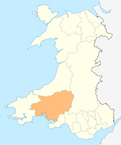 | ||
|---|---|---|---|
| Towns and villages |
| ||
| Buildings and structures |
| ||
| Rivers | |||
| Topics |
| ||
This article is issued from Wikipedia - version of the 10/5/2016. The text is available under the Creative Commons Attribution/Share Alike but additional terms may apply for the media files.