Pumsaint
Coordinates: 52°02′49″N 3°57′40″W / 52.047°N 3.961°W Pumsaint is a village in Carmarthenshire, Wales situated half way between Llanwrda and Lampeter on the A482 in the valley of the River Cothi. It forms part of the extensive estate of Dolaucothi which is owned by the National Trust.
.jpg)
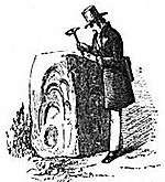
Its name means Five Saints derived from the Welsh Pum(p) meaning Five and Saint meaning Saint. The name is derived from the stone block at the nearby gold mines, opposite Ogofau Lodge, which has four sides, each of which has hollows probably caused by pestle impacts. It was used as an anvil for crushing gold ore in the Roman period. Excavations in the 1990s of the area adjacent to the stone showed that the stone was originally horizontal and used as an anvil for a water powered crushing mill. There are many parallels from Spanish mines of the Roman period with similar stone anvils. It is also sometimes known as the Pumpsaint.
Places of interest
.jpg)
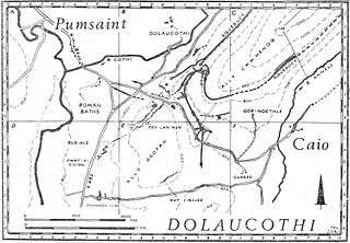
The nearby conservation area has several scheduled ancient monuments including the Dolaucothi Gold Mines. Archaeologists have uncovered evidence of Roman occupation of the area, including Roman aqueducts, numerous tanks, cisterns and reservoirs, timber buildings and a fort. There are also extensive underground workings which can be viewed in guided tours organised by the National Trust. Archaeology suggests that gold extraction on this site may have started sometime in the Bronze Age, possibly by washing of the gold-bearing gravels of the river Cothi, the most elementary type of gold prospecting. Sextus Julius Frontinus was sent into Roman Britain in 74 AD to succeed Quintus Petillius Cerialis as governor. He subdued the Silures, Demetae and other hostile tribes of Roman Wales, establishing a new base at Caerleon for Legio II Augusta and a network of smaller Roman forts fifteen to twenty kilometres apart for his Roman auxiliary units. During his tenure, he probably established the fort at Pumsaint in west Wales, largely to exploit the gold deposits at Dolaucothi. Frontinus later restored the Aqueducts of Rome.
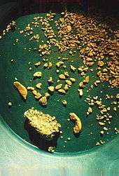
That gold occurred here is shown by the discovery of a hoard of gold ornaments in the 18th century. Objects found included a wheel brooch and snake bracelets, so named because they were soft enough to be coiled around the arm for display. All the objects are now held in the British Museum, and displayed in the Romano-British gallery. A sample of gold ore was found at the site by Henry de la Beche in 1844, confirming the presence of gold.
Evidence from the fort (known as Luentinum from details given by Ptolemy) and vicus show that the Romans worked the mine during the 1st and 2nd centuries AD (from c. AD 78 until around AD 125), judging by the occupation of the fort. However coarse ware and Samian ware pottery recovered from a reservoir (Melin-y-Milwyr) within the mine complex show that activity at the mines continued until the late 3rd century at least. Since Ptolemy's map dates to about 150 AD, it is likely then that it continued being worked until the end of the 3rd century if not beyond. The Romans made extensive use of water carried by several aqueducts and leats (the longest of which is about 7 miles from its source in a gorge of the river) to prospect for the gold veins hidden beneath the soil on the hillsides above the modern village of Pumsaint. Small streams on Mynydd Mallaen, the Annell and Gwenlais, were used initially to provide water for prospecting, and there are several large tanks for holding the water still visible above an isolated opencast pit carved in the side of the hill north of the main site. The water was used in a method known as hushing, where a wave is released to sweep soil and sub-soil away to reveal bare rock. The method was also used to remove as rock debris after a vein was attacked using tools and fire-setting to produce the opencast. The larger aqueduct from the Cothi crosses this opencast, proving the opencast to be earlier.
Other attractions
Other places of interest include the Red Kite Visitor Centre, located in the Old Coach House in the center of the village, where displays on the oak woodlands, the traditional nesting place of the bird, may be viewed. To the north up the Cothi valley and across the watershed into the Tywi valley lies the large dam of Llyn Brianne and the wilderness beyond is good pony trekking country.
The area is a popular place for caravan, fishing and riding holidays.
See also
External links
- Carreg Pumsaint – once thought to be a 'standing stone' now thought to be an anvil for crushing gold ore
- www.geograph.co.uk : photos of Pumsaint and surrounding area