Ratho
| Ratho | |
| Scottish Gaelic: Ràthach | |
 St Mary's Kirk in Ratho |
|
 Ratho |
|
| Population | 1,634 |
|---|---|
| OS grid reference | NT1370 |
| Council area | City of Edinburgh |
| Lieutenancy area | Edinburgh |
| Country | Scotland |
| Sovereign state | United Kingdom |
| Post town | NEWBRIDGE |
| Postcode district | EH28 |
| Dialling code | 0131 |
| Police | Scottish |
| Fire | Scottish |
| Ambulance | Scottish |
| EU Parliament | Scotland |
| UK Parliament | Edinburgh West[1] |
| Scottish Parliament | Edinburgh Western[2] |
Coordinates: 55°55′19″N 3°22′44″W / 55.922°N 3.379°W
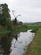
Ratho (Scottish Gaelic: Ràthach) is a village in the Rural West Edinburgh area of Edinburgh, Scotland. Its population at the 2011 census was 1,634 based on the 2010 definition of the locality.[3] It was formerly in the old county of Midlothian. Newbridge and Kirkliston are other villages in the area. The Union Canal passes through Ratho. Edinburgh Airport is situated only 4 miles (7 km) away. The village has a high ratio of its older houses built from whin stone due to a whin quarry nearby. The older, historical, part of the village was designated a Conservation Area in 1971 by Midlothian County Council.[4]
Origins


Ratho appears in written records from 1243 with various spellings such as Rath(ewe, eu, ew, ow, au) but most consistently, from 1292, with its present name Ratho. Other places nearby having "Ratho" in their names include Ratho Byres, Ratho Park and Ratho Bank (now named Ashley).
It is believed that the name Ratho comes from Rath, Scottish Gaelic, for a place where there are hill forts. Both Kaimes and Dalmahoy hill forts are nearby.
To the southwest of the village, Tormain Hill is the site of stone age symbols carved into the rocks atop the hill and a 'witches' stone'.[5][6] When the witches' stone was moved by the land owner for farming, it was believed evil spirits were released into the village.
Haltoun House
There are a number of old buildings in the area. The most prominent of these was Haltoun House or castle (pronounced, and sometimes spelt, Hatton), which was badly damaged by fire in the mid-1950s and subsequently taken down. This magnificent country house evolved from its central core, a Norman keep, or what Scots call a Pele Tower. In 1371 the manor and lands of Haltoun were resigned to the Crown by John de Haltoun, and were regranted to Alan de Lawedre [Lauder] of that Ilk who then resided mostly at Whitslaid Tower just outside Lauder. Haltoun Tower was damaged during the House of Douglas troubles of 1452, when a note in the Treasurers' Accounts show funds being provided for its repair. The Haltoun estates remained in the Lauder family until the latter half of the 17th century when they passed by marriage to Charles Maitland, 3rd Earl of Lauderdale, who enlarged and beautified Hatton House.
Parish Church (St Marys)

There is evidence of a pre-Norman, Celtic church on this site, and reference to St Mary's in Ratho date back to 1243.[7]
The east aisle is dated 1683. West of the south aisle (1830) half of an ornate 12th century doorway is still visible. Generally the church has never been grand, but it bears the hallmarks of centuries of evolutionary change. The interior was generally denuded in 1932 including loss of the 18th century gallery. A 13th century memorial lies in the south porch.[8] One curious feature is the bell, which was rung by an external chain which has carved a groove into the stonework below the bell.
The churchyard is of equal antiquity and interest. Its greatest oddity is a gravestone to John Mitchell who died in 1749 aged 80 years. He was a mason by trade and the gravestone was cut out many years before he died in the form of a panelled coffin.[9][10] Richard Lauder, the last Lauder laird of Haltoun, was interred in the graveyard on November 29, 1675. Other graves of note are Thomas Wilkie (d.1679), William Anderson (d.1756) and the Rev Andrew Duncan (d.1827) (Moderator of the Church of Scotland in 1824).
The manse is a very fine two storey Georgian villa standing to the east on the opposite side of the main road. It dates from around 1790 and is constructed of whin stone. It faces southwards, away from the road. Its outbuildings have been converted into a separate house now slightly separating it from the church.
A new cemetery of far less character now lies on the NE outskirts of the village, slightly out of sight from the churchyard, just east of the manse.
Transport

Lothian Buses
20 Ratho - Gyle Centre - Edinburgh Park - Sighthill - Wester Hailes - Kingsknowe - Slateford
E&M Horsburgh
40/X40 East Calder - Livingston = St John's Hospital - Broxburn - Newbridge - Ratho - Royal Infirmary
Ratho is located close to both the M8 and the M9 motorways. The A8 and A71 run parallel to the north and the south of the village. These are two of the major roads running into Edinburgh. There is a network of paths around Ratho and the surrounding area, and you can also walk or cycle along the canal towpath.
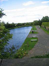
Union Canal
The Union Canal was built through the area from 1818 to 1822.[7]
Ratho is the location of Edinburgh Canal Centre, founded in 1989 by Ronnie Rusack. The Seagull Trust is a boating charity offering free cruises to disabled people since 1979. It also boasts the only dry dock on the Union Canal. On either side of Bridge 15 are a series of artworks relating to the canal's history. Many of these can be used as seating.
"Baird Road" commemorates Hugh Baird who designed the canal.
Lin’s Mill
West of Ratho stands a small group of mill buildings dating from around 1600. A group of rubble-built cottages sited at right angles to the mill were demolished in the 1960s reducing the size of the group.
Conversion to a house in 1971 by Morris and Steadman greatly reduced its historic significance and it is listed category C.
In the wood above Lin's Mill is the grave of William Lin reputed to be the last man in Scotland to die of the plague (but many similar plague graves exist from that year). The grave is marked by a slab with a crude coat of arms, memento mori and the inscription "Here lyeth the dust of William Lin right heritor of Linsmiln who died in the year of the lord 1645".
The nearby Almond Aqueduct on the Union Canal is also known as the Lin's Mill Aqueduct.[11]
Edinburgh International Climbing Arena

Edinburgh International Climbing Arena, the largest indoor climbing centre in Europe, and one of the biggest in the world, opened in October 2004 in the long-disused Ratho Quarry near Ratho, on the bank of the Union Canal. The centre was closed for the end of 2006 and partially open for the first quarter of 2007. It has had some major works completed and is now fully operational. It boasts 2,400m² of artificial climbing surface, including 400m² of free-standing boulders, there are also plans for an additional bouldering room, however which was to open around July 2007. The centre is unique in its use of covered natural rock. Competitive and amateur climbers are attracted from around the world and the centre provides training up to World Cup competition standard. Above the climbing arena is SkyRide, a 150m aerial assault course taking 10–30 minutes. In addition there is also a large gym, with new equipment and a spa facility.
Ratho climbing centre was inspired and designed by Edinburgh based architect David Taylor and was assisted by experienced climbers Rab Anderson and Duncan McCallum.
Notable Residents
- James Anderson of Hermiston
- Sir John Gibson
- Thomas Grainger
- Alexander Lauder
- Alexander Lauder of Blyth
- John Maitland, 5th Earl of Lauderdale
- James Maitland, 8th Earl of Lauderdale
- William Serle
- William Grant Stevenson (sculptor)
- David Watson Stevenson (sculptor)
- Ebenezer James MacRae (architect)
- William Wilkie, poet.
Photo gallery
|


References
- ↑ "Edinburgh West" (PDF). Boundary Commission for Scotland. Retrieved 5 December 2014.
- ↑ "Edinburgh Western" (PDF). Boundary Commission for Scotland. Retrieved 5 December 2014.
- ↑ "Ratho (City of Edinburgh)". Retrieved 2014-06-21.
- ↑ "Ratho Conservation Area Character Appraisal" (PDF). Retrieved 2014-06-21.
- ↑ Smith, John Alexander (1872–74). "Notes of Rock Sculpturings of Cups and Concentric rings, and 'The Witch's Stone' on Tormain Hill; also of some Early Remains on the Kaimes Hill, &c., near Ratho, Edinburghshire." (PDF). Proceedings of the Society of Antiquaries Scotland. 10: 141–51.
- ↑ Allen, J Romilly (1881–82). "Notes on some Undescribed Stones with Cup-Markings in Scotland." (PDF). Proceedings of the Society of Antiquaries Scotland. 16: 79–85.
- 1 2 Ratho Conservation Area Appraisal, CEC
- ↑ Buildings of Scotland: Lothian by Colin Mcwilliam
- ↑ "Canmore - Item SC 587510". Retrieved 2014-06-21.
- ↑ "RATHO VILLAGE, BAIRD ROAD, RATHO KIRK, ST MARY'S CHURCH WITH SESSION HOUSE, GRAVEYARD, WALLS AND GATEPIERS (Ref:27685)". Retrieved 2014-06-21.
- ↑ "Lin's Mill and House (Ref:27553)". Listed Buildings. Historic Scotland. Retrieved 2015-05-11.
External links
| Wikimedia Commons has media related to Ratho. |
| Wikimedia Commons has media related to Edinburgh International Climbing Arena. |
- Seagull Trust, boating charity offering free boating for disabled people
- The Edinburgh International Climbing Arena: Ratho
- Ratho on Google Maps - The M8 is visible to the north and the Union Canal runs west to east. The Climbing Arena is clearly visible between the two, and Ratho itself is to the east.
