Greenhill, Edinburgh

Greenhill is a small area of Edinburgh, the capital of Scotland. Situated south west of the city centre, Greenhill is normally taken to be part of Bruntsfield, which skirts it to the north. Greenhill borders Marchmont and The Grange to the east, Morningside to the south, and Merchiston, beyond Holy Corner, to the west. It comprises a mixture of Georgian and Victorian villas and some tenement housing.
History
The name derives from the former estate of Greenhill, which was one of the original lots purchased when the Edinburgh magistrates feued the Burgh Muir in 1586. The owner was Thomas Aikenhead, an Edinburgh merchant. Two further lots were later added to the original portion of Greenhill, including the ground that became known as Burghmuirhead, and sold to separate owners, one of whom was William Rig. Aikenhead was a skinner (glover) by occupation and held the positions of councillor, bailie and Dean of Guild. In 1636, the estate was sold to John Livingston, an Edinburgh apothecary whose family had become connected to the Aikenheads by marriage. His wife, Elizabeth Rig, appears to have been a relation of William Rig above.[1]
Features

A stone carving depicting the former manor house may still be seen on the wall of a tenement house at the corner of Bruntsfield Place and Bruntsfield Gardens.
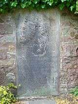
A walled, roofless structure rebuilt some time after 1894 is the mausoleum of John Livingstone,[2] an apothecary and former laird of the estate. It was paid for by his widow Elizabeth Rig. It stood in the grounds of the manor house before its demolition and is now situated adjacent to a smaller private Victorian villa. A tombstone carries the date 1645.[3] The roughly square area contains an information plaque, memorial bench, and plants. Its continued existence was the subject of a bitter legal dispute after the villa changed ownership.[4]
Parking
In 2006 the Greenhill area was brought into the "S2" (southern zone 2) controlled parking zone, making the majority of roadside parking available only to residents paying Council Tax and purchasing a permit. This was done in conjunction with an expansion of the controlled parking zone across the city (see transport in Edinburgh).
See also
References
- ↑ W Mair, Historic Morningside, Edinburgh 1947, p.7-8
- ↑ Historic Scotland listing for the Livingstone Mausoleum
- ↑ RCAHMS record for the Livingstone Mausoleum
- ↑ Edinburgh Evening News article: "Facelift as land-feud garden prepares to reopen to public", 25 September 2006 After a lengthy campaign by local residents and local MSP Mike Pringle in 2009, it was confirmed by the Lands Tribunal for Scotland to be owned by the local authority.Edinburgh Evening News article: "Couple lose legal fight over ownership of historic tomb", 4 February 2009
External links
- Merchiston Community Council (which covers Greenhill)
- Google Maps

Coordinates: 55°56′2″N 3°12′28″W / 55.93389°N 3.20778°W