Rapidan, Virginia
| Rapidan, Virginia | |
|---|---|
| Unincorporated community | |
 Rapidan  Rapidan Location in Virginia | |
| Coordinates (city): 38°18′45″N 78°03′57″W / 38.31250°N 78.06583°WCoordinates: 38°18′45″N 78°03′57″W / 38.31250°N 78.06583°W | |
| Country |
|
| State |
|
| County | Culpeper & Orange |
| Established | Mid to late 1700s |
| Area | |
| • Total | 49 sq mi (130 km2) |
| Elevation | 430[1] ft (131 m) |
| Population (2010) | |
| • Total | 1,469[1] |
| • Density | 30/sq mi (10/km2) |
| Time zone | EST (UTC-5) |
| • Summer (DST) | EDT (UTC-4) |
| ZIP code | 22733 |
| Area code(s) | 540 |
Rapidan is a small unincorporated community in the Virginia counties of Culpeper and Orange, approximately 5 miles (8 km) northeast of the Town of Orange. The community, located on both sides of the Rapidan River, was established in the late eighteenth century around the Waugh's Ford mill. The Orange and Alexandria Railroad built a line through the town in 1854, a post office was built at the river crossing, and its name was changed to Rapid Ann Station. Milling remained a major industry in the area up through the mid-twentieth century.[2]
Its strategic location along both a railroad and a river brought about several destructive raids during the Civil War. Willis’s mill (ca. 1772), which stood in the location of the current mill, was burned along with several homes and other structures, although the miller's house remained.[2] The village of Rapid Ann Station resumed its prominence as a regional shipping point after the railroad was rebuilt following the civil war, particularly for lumber and wood products. Its name was changed once again in 1886 to the present-day Rapidan.[2]
In 1987, the Rapidan Historic District, encompassing 35 contributing buildings and 3 noncontributing buildings within 182 acres (74 ha), was designated a National Historic District, added to both the Virginia Landmarks Register (VLR) and the National Register of Historic Places (NRHP). Contributing buildings include the Waddell Memorial Presbyterian Church, listed separately on the VLR and NRHP. Although not within the Rapidan Historic District, the community of Rapidan is also home to an eighteenth-century middle-class farmhouse known as Locust Grove (also known as Goodwin farm), which was listed on the VLR and NRHP in 1985.[2][3]
The community and surrounding counties are served by the Rapidan Volunteer Fire Department, officially formed in 1978.[4]
 Emmanuel Episcopal Church
 Lower Rapidan Baptist Church
 Waddell Memorial Presbyterian Church
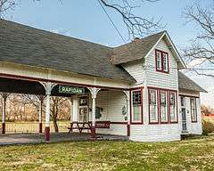 Rapidan Passenger Depot
Climate
The climate in this area is characterized by hot, humid summers and generally mild to cool winters. According to the Köppen Climate Classification system, Rapidan has a humid subtropical climate, abbreviated "Cfa" on climate maps.[5]
See also
References
- 1 2 Zip code 22733 Data (Rapidan, VA). Retrieved 16 November 2013. https://www.zip-codes.com/zip-code/22733/zip-code-22733.asp
- 1 2 3 4 "Rapidan Historic District." National Register of Historic Places registration form. February 1986. Form prepared by David Edwards and staff, Virginia Division of Historic Landmarks. Retrieved 15 November 2013. http://www.dhr.virginia.gov/registers/Counties/Culpeper/023-0052_Rapidan_Historic_District_1987_Final_Nomination.pdf
- ↑ "Locust Grove (Goodwin farm)." National Register of Historic Places registration form. June 1985. Form prepared by the Virginia Division of Historic Landmarks. Retrieved 15 November 2013. http://www.dhr.virginia.gov/registers/Counties/Culpeper/023-0049_Locust_Grove_1985_Final_Nomination.pdf
- ↑ "RVFD History". Rapidan Volunteer Fire Department. Retrieved 2007-12-28.
- ↑ Climate Summary for Rapidan, Virginia
Municipalities and communities of Culpeper County, Virginia, United States | ||
|---|---|---|
| Town |  | |
| Unincorporated communities | ||