R575 road (Ireland)
| ||||
|---|---|---|---|---|
|
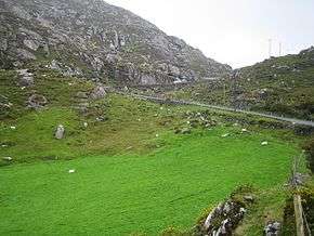
R575 at Reentrusk, Co. Cork | ||||
| Route information | ||||
| Length: | 19.0 km[1][2] (11.8 mi) | |||
| Major junctions | ||||
| From: |
| |||
| To: |
| |||
| Road network | ||||
| ||||
The R575 road is a regional road in Ireland. It is a road on the Beara Peninsula in County Cork.[1][2] The road forms part of the Wild Atlantic Way.[3] Parts of the road form part of the Beara Way walking trail.[4]
Hillsides by the road near Allihies are marked by ruins of former copper mines. The mines were at peak production in the 19th century but some were operational until 1962.[5]
The R575 travels northeast from the R572 via Allihies and along the Kenmare River inlet.[5] The road ends at the R571 near Eyeries. The R575 is 19.0 km (11.8 mi) long.[1]
References
- 1 2 3 Google (19 May 2016). "R572 to R571" (Map). Google Maps. Google. Retrieved 19 May 2016.
- 1 2 "S.I. No. 54/2012 – Roads Act 1993 (Classification of Regional Roads) Order 2012". Government of Ireland. 28 Feb 2012. Retrieved 19 May 2016.
- ↑ "Wild Atlantic Way: Explore The Route". Fáilte Ireland. Retrieved 19 May 2016.
- ↑ "The Beara Way". Ireland View. Retrieved 1 Jun 2016.
- 1 2 Poole, Susan; Gallagher, Lyn (2008). AA Best Drives Ireland. The Automobile Association. pp. 43–44. ISBN 978-0-7495-4430-0.
This article is issued from Wikipedia - version of the 6/4/2016. The text is available under the Creative Commons Attribution/Share Alike but additional terms may apply for the media files.