Quitman, Mississippi
| Quitman, Mississippi | |
|---|---|
| City | |
|
Clarke County Courthouse in Quitman | |
| Motto: "A Very Special Place To Call Home"[1] | |
 Location of Quitman, Mississippi | |
 Quitman, Mississippi Location in the United States | |
| Coordinates: 32°2′35″N 88°43′15″W / 32.04306°N 88.72083°WCoordinates: 32°2′35″N 88°43′15″W / 32.04306°N 88.72083°W | |
| Country | United States |
| State | Mississippi |
| County | Clarke |
| Area | |
| • Total | 5.9 sq mi (15.3 km2) |
| • Land | 5.2 sq mi (13.4 km2) |
| • Water | 0.7 sq mi (1.9 km2) |
| Elevation | 230 ft (70 m) |
| Population (2010) | |
| • Total | 2,323 |
| • Density | 449/sq mi (173.2/km2) |
| Time zone | Central (CST) (UTC-6) |
| • Summer (DST) | CDT (UTC-5) |
| ZIP code | 39355 |
| Area code(s) | 601 |
| FIPS code | 28-60720 |
| GNIS feature ID | 0676438 |
| Website |
www |

Quitman is a city in Clarke County, Mississippi, United States, along the Chickasawhay River. The population was 2,323 at the 2010 census.[2] Quitman is the county seat of Clarke County.[3][4]
History
Quitman was established in 1839.[1]
Geography
Quitman is located near the center of Clarke County at 32°2′35″N 88°43′15″W / 32.04306°N 88.72083°W (32.043004, -88.720867).[5] U.S. Route 45, a four-lane divided highway, bypasses the city to the east and leads north to Meridian and south to Waynesboro. Mississippi Highway 18 passes through the center of the city, departing south from the town but then turning northwest to Pachuta and Interstate 59, and leading east to the Alabama border. Mississippi Highway 145 represents the old alignment of US 45 and intersects Highway 18 in the center of town.
According to the United States Census Bureau, the city has a total area of 5.9 square miles (15.3 km2), of which 5.2 square miles (13.4 km2) is land and 0.73 square miles (1.9 km2), or 12.28%, is water.[2]
Climate
| Climate data for Quitman | |||||||||||||
|---|---|---|---|---|---|---|---|---|---|---|---|---|---|
| Month | Jan | Feb | Mar | Apr | May | Jun | Jul | Aug | Sep | Oct | Nov | Dec | Year |
| Average high °F (°C) | 56.6 (13.7) |
62.0 (16.7) |
69.2 (20.7) |
77.5 (25.3) |
83.9 (28.8) |
89.7 (32.1) |
91.9 (33.3) |
91.5 (33.1) |
87.0 (30.6) |
77.8 (25.4) |
68.6 (20.3) |
60.0 (15.6) |
76.3 (24.6) |
| Average low °F (°C) | 32.9 (0.5) |
36.1 (2.3) |
42.6 (5.9) |
50.3 (10.2) |
58.2 (14.6) |
65.1 (18.4) |
68.5 (20.3) |
67.6 (19.8) |
62.3 (16.8) |
49.2 (9.6) |
41.6 (5.3) |
35.4 (1.9) |
50.8 (10.4) |
| Average precipitation inches (mm) | 5.5 (140) |
4.9 (124) |
6.1 (155) |
5.3 (135) |
4.0 (102) |
4.0 (102) |
5.1 (130) |
3.5 (89) |
3.8 (97) |
3.2 (81) |
4.0 (102) |
5.3 (135) |
54.8 (1,392) |
| Source: Weatherbase [6] | |||||||||||||
Demographics
| Historical population | |||
|---|---|---|---|
| Census | Pop. | %± | |
| 1880 | 410 | — | |
| 1890 | 395 | −3.7% | |
| 1900 | 498 | 26.1% | |
| 1910 | 950 | 90.8% | |
| 1920 | 1,375 | 44.7% | |
| 1930 | 1,872 | 36.1% | |
| 1940 | 1,471 | −21.4% | |
| 1950 | 1,817 | 23.5% | |
| 1960 | 2,030 | 11.7% | |
| 1970 | 2,702 | 33.1% | |
| 1980 | 2,632 | −2.6% | |
| 1990 | 2,736 | 4.0% | |
| 2000 | 2,463 | −10.0% | |
| 2010 | 2,323 | −5.7% | |
| Est. 2015 | 2,209 | [7] | −4.9% |
As of the census[9] of 2000, there were 2,463 people, 975 households, and 674 families residing in the city. The population density was 475.9 people per square mile (183.6/km²). There were 1,097 housing units at an average density of 212.0 per square mile (81.8/km²). The racial makeup of the city was 45.26% White, 53.25% African American, 0.08% Native American, 0.04% Asian, 0.08% from other races, and 0.28% from two or more races. Hispanic or Latino of any race were 0.41% of the population.
There were 975 households out of which 29.4% had children under the age of 18 living with them, 47.9% were married couples living together, 19.0% had a female householder with no husband present, and 30.8% were non-families. 28.6% of all households were made up of individuals and 12.3% had someone living alone who was 65 years of age or older. The average household size was 2.37 and the average family size was 2.87.
In the city the population was spread out with 24.4% under the age of 18, 7.8% from 18 to 24, 22.9% from 25 to 44, 22.5% from 45 to 64, and 22.5% who were 65 years of age or older. The median age was 41 years. For every 100 females there were 80.8 males. For every 100 females age 18 and over, there were 75.4 males.
The median income for a household in the city was $30,469, and the median income for a family was $38,311. Males had a median income of $28,250 versus $21,833 for females. The per capita income for the city was $14,789. About 16.9% of families and 23.3% of the population were below the poverty line, including 41.2% of those under age 18 and 9.7% of those age 65 or over.
Education
The city is served by the Quitman School District.[10][11]
Notable people
Quitman is the hometown of ex-NBA power forward Antonio McDyess[12] and the birthplace of writer Wyatt Emory Cooper.[13]
References
- 1 2 "The City of Quitman Mississippi". The City of Quitman Mississippi. Retrieved October 10, 2012.
- 1 2 "Geographic Identifiers: 2010 Demographic Profile Data (G001): Quitman city, Mississippi". U.S. Census Bureau, American Factfinder. Retrieved October 6, 2014.
- ↑ "Find a County". National Association of Counties. Archived from the original on May 31, 2011. Retrieved 2011-06-07.
- ↑ "Profile for Quitman, Mississippi, MS". ePodunk. Retrieved October 10, 2012.
- ↑ "US Gazetteer files: 2010, 2000, and 1990". United States Census Bureau. 2011-02-12. Retrieved 2011-04-23.
- ↑ "Weatherbase: Historical Weather for Quitman, Mississippi". Weatherbase. 2011. Retrieved on November 24, 2011.
- ↑ "Annual Estimates of the Resident Population for Incorporated Places: April 1, 2010 to July 1, 2015". Retrieved July 2, 2016.
- ↑ "Census of Population and Housing". Census.gov. Archived from the original on May 11, 2015. Retrieved June 4, 2015.
- ↑ "American FactFinder". United States Census Bureau. Archived from the original on September 11, 2013. Retrieved 2008-01-31.
- ↑ "Quitman School District". Quitman School District. Archived from the original on August 26, 2012. Retrieved October 10, 2012.
- ↑ "Quitman School District". Great Schools Inc. Retrieved October 10, 2012.
- ↑ "Antonio McDyess". Baseball-Reference.Com. Retrieved October 10, 2012.
- ↑ "Wyatt Cooper". IMDb. Retrieved October 10, 2012.
External links
- The Quitman Villager
- City-Data.com
- Quitman School District
- ePodunk: Profile for Quitman, Mississippi
Municipalities and communities of Clarke County, Mississippi, United States | ||
|---|---|---|
| City | 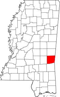 | |
| Towns | ||
| Unincorporated communities | ||
| Ghost town | ||