Quinebaug River Prehistoric Archeological District
|
Quinebaug River Prehistoric Archeological District | |
|
2009 dig of Native American fishing village conducted by State Archeologist and UCONN | |
  | |
| Location |
Between Rt. 169 and the Quinebaug River Canterbury, Connecticut |
|---|---|
| Area | 22 acres (8.9 ha) |
| NRHP Reference # | 09000696[1] |
| Added to NRHP | September 7, 2009 |
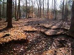
The Quinebaug River Prehistoric Archeological District encompasses a collection of prehistoric archaeological sites near the Quinebaug River in Canterbury, Connecticut. The district covers 22 acres (8.9 ha) of state-owned land on the west bank of the river, east of Connecticut Route 169 south of Connecticut Route 14 and north of Connecticut Route 668. Five separate sites with architectural significance were identified in this area during survey wor conducted in the area in 2001 and 2002. The sites range in size from 6.4 acres (2.6 ha) to just 0.25 acres (0.10 ha), with stone finds dating mainly to the Woodland Period. Two of the sites exhibit evidence of Late Archaic occupation, and all are likely to provide additional information through further excavation.[2]
The district was listed on the National Register of Historic Places in 2009.[1]
See also
References
- 1 2 National Park Service (2010-07-09). "National Register Information System". National Register of Historic Places. National Park Service.
- ↑ "NRHP nomination for Quinebaug River Prehistoric Archeological District" (PDF). National Park Service. Retrieved 2015-01-15.
| Lists by county |  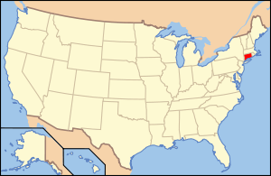 | |
|---|---|---|
| Lists by city or town | ||
| Other lists | ||
Coordinates: 41°40′24″N 71°57′26″W / 41.6732°N 71.9571°W