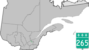
Quebec Route 265
| ||||
|---|---|---|---|---|
 | ||||
| Route information | ||||
| Length: | 49.0 km[1] (30.4 mi) | |||
| Major junctions | ||||
| North end: |
| |||
|
| ||||
| South end: |
| |||
| Location | ||||
| Major cities: | Villeroy, Plessisville | |||
| Highway system | ||||
| ||||

Route 265 is a two-lane north/south highway on the south shore of the Saint Lawrence River in Quebec, Canada. Its northern terminus is in Deschaillons at the junction of Route 132, and the southern terminus is at the junction of Route 165 in Plessisville. It used to continue up to Black Lake (now part of Thetford Mines) at the junction of Route 112, but the segment between Plessisville and Black Lake was later re-numbered to Route 165 in the 1990s.
Towns along Route 265
- Deschaillons-sur-Saint-Laurent
- Parisville
- Fortierville
- Sainte-Françoise-de-Lotbinière
- Villeroy
- Notre-Dame-de-Lourdes
- Plessisville
See also
References
- ↑ Ministère des transports, "Distances routières", page (?), Les Publications du Québec, 2005
External links
- Route 265 on Google Maps
- Provincial Route Map (Courtesy of the Quebec Ministry of Transportation) (French)
This article is issued from Wikipedia - version of the 11/9/2016. The text is available under the Creative Commons Attribution/Share Alike but additional terms may apply for the media files.