Quebec Route 161
| ||||
|---|---|---|---|---|
 | ||||
| Route information | ||||
| Maintained by Transports Québec | ||||
| Length: | 187.6 km[1] (116.6 mi) | |||
| Major junctions | ||||
| South end: |
| |||
|
| ||||
| North end: | Rue Principale in Saint-Wenceslas | |||
| Location | ||||
| Major cities: | Victoriaville | |||
| Highway system | ||||
| ||||

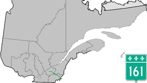
Route 161 is a north/south highway south of the St. Lawrence River in Quebec, Canada. Its current northern terminus is east of the junction of Autoroute 55 in Saint-Wenceslas, and its southern terminus is at the border of Maine in the USA, where it continues as Maine State Route 27.
On July 6, 2013, the route was severed at Lac-Mégantic, Quebec by an oil train derailment. Ministry of Transport consultants began surveying a site for a new bridge across the Chaudière River in August 2013.[2]
Municipalities along Route 161
- Saint-Augustin-de-Woburn
- Frontenac
- Lac-Mégantic
- Nantes
- Stornoway
- Stratford
- Weedon
- Beaulac-Garthby
- Saints-Martyrs-Canadiens
- Ham-Nord
- Notre-Dame-de-Ham
- Chesterville
- Saint-Christophe d'Arthabaska
- Victoriaville
- Saint-Valère
- Saint-Samuel
- Sainte-Eulalie
- Saint-Wenceslas
See also
References
- ↑ Ministère des transports, "Distances routières", page 73, Les Publications du Québec, 2005
- ↑ http://www.radio-canada.ca/regions/estrie/2013/08/17/003-megantic-travaux-relocalisation.shtml
External links
- Interactive Provincial Route Map (Transports Québec) (French)
- Route 161 on Google Maps
This article is issued from Wikipedia - version of the 11/9/2016. The text is available under the Creative Commons Attribution/Share Alike but additional terms may apply for the media files.