Quebec Route 159
| ||||
|---|---|---|---|---|
 | ||||
| Route information | ||||
| Maintained by Transports Québec | ||||
| Length: | 61.3 km[1] (38.1 mi) | |||
| Major junctions | ||||
| South end: |
| |||
|
| ||||
| North end: |
| |||
| Location | ||||
| Counties: | Les Chenaux / Mékinac | |||
| Major cities: | Sainte-Anne-de-la-Pérade, Saint-Tite | |||
| Highway system | ||||
| ||||

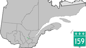
Provincial Highway 159 (or Route 159) is a two-lane north/south highway on the north shore of the Saint Lawrence River in Quebec, Canada. Its northern terminus is in Saint-Roch-de-Mékinac at the junction of Route 155, and the southern terminus is at the junction of Route 138 in Sainte-Anne-de-la-Pérade.
Municipalities along Route 159
- Sainte-Anne-de-la-Pérade
- Saint-Prosper-de-Champlain
- Saint-Stanislas
- Saint-Séverin
- Saint-Tite
- Saint-Roch-de-Mékinac
Major Intersection
| RCM or ET | Municipality | Km | Junction | Notes |
|---|---|---|---|---|
Southern terminus of Route 159 | ||||
| Les Chenaux | Sainte-Anne-de-la-Pérade | 0.0 | 138 WEST: to Batiscan 138 EAST: to Deschambault-Grondines | |
| 0.8 1.4 |
40 EAST: to Portneuf 40 WEST: to Trois-Rivières | |||
| 3.4 | 354 EAST: to Saint-Casimir | |||
| Saint-Prosper-de-Champlain | 10.5 | Chemin de la Rivière-à-Veillet | WEST: to Sainte-Geneviève-de-Batiscan | |
| Saint-Stanislas | 19.9 20.6 |
352 WEST: to Saint-Narcisse 352 EAST: to Saint-Adelphe | ||
| Mékinac | Saint-Tite | 41.4 42.8 |
153 NORTH: to Sainte-Thècle 153 SOUTH: to Hérouxville | |
| Saint-Roch-de-Mékinac | 61.3 | 155 SOUTH: to Grandes-Piles 155 NORTH: to Trois-Rives | ||
Northern terminus of Route 159 | ||||
See also
References
- ↑ Ministère des transports, "Distances routières", page 72-73, Les Publications du Québec, 2005
External links
- Interactive Provincial Route Map (Transports Québec) (French)
- Route 159 on Google Maps
This article is issued from Wikipedia - version of the 11/9/2016. The text is available under the Creative Commons Attribution/Share Alike but additional terms may apply for the media files.