Punavuori
| Punavuori Rödbergen | |
|---|---|
| Helsinki Subdivision | |
 Position of Punavuori within Helsinki | |
| Country |
|
| Region | Uusimaa |
| Sub-region | Greater Helsinki |
| Municipality | Helsinki |
| Subdivision number | 05 |
| District | Southern |
| Subdivision regions | none |
| Area | 0.42 km2 (0.16 sq mi) |
| Population (2010) | 8,440 |
| Postal codes | 00120, 00150 |
| Neighbouring subdivisions |
Kaartinkaupunki Kamppi Eira Ullanlinna Munkkisaari |
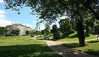
Punavuori (Swedish: Rödbergen) is a neighbourhood in Helsinki, the capital of Finland. The name Punavuori (English: Red mountain) refers to red cliffs located between Sepänkatu and Punavuorenkatu. They were still visible in the 19th century, nowadays they are covered with buildings and pavement. Punavuori was traditionally a working-class neighbourhood, today it is known as a bohemian district popular among artists, students and hipsters. It is one of the most densely populated areas in Finland.
After the new location and growth of Helsinki in the 18th century, Punavuori became the area next to the center. During the 19th century the district had a seedy reputation. Most of the brothels and beerhouses were found in Punavuori. The social problems were aggravated by quickly built rent-apartments for the poor.

After World War II, the district went through a process of gentrification. Today Punavuori offers many trendy small shops and bars, nightclubs and restaurants. Important streets include Uudenmaankatu and Iso Roobertinkatu. In the old Helsinki slang, the district is called "Rööperi" (derived from the district's Swedish name).
In popular culture
A Finnish cover version of The Beatles' song "Penny Lane" has lyrics referring to Punavuori. The song is called "Rööperiin" which means "To Punavuori", using the slang term derived from the Swedish name. The song has been recorded by Pepe Willberg (and later by other artists). The lyrics for the chorus part are: "Rööperiin, mä kaipaan niin" ("I yearn for Punavuori").
External links
![]() Media related to Punavuori at Wikimedia Commons
Media related to Punavuori at Wikimedia Commons
Coordinates: 60°09′42″N 024°56′17″E / 60.16167°N 24.93806°E